IMAGES TAKEN NEAR TO
Ballyartan Road, STRABANE, BT82 0PX
Introduction
This page details the photographs taken nearby to Ballyartan Road, BT82 0PX by members of the Geograph project.
The Geograph project started in 2005 with the aim of publishing, organising and preserving representative images for every square kilometre of Great Britain, Ireland and the Isle of Man.

There are currently over 7.5m images from over14,400 individuals and you can help contribute to the project by visiting https://www.geograph.org.uk
Image Map
Images are licensed for reuse under creativecommons.org/licenses/by-sa/2.0
Notes
- Clicking on the map will re-center to the selected point.
- The higher the marker number, the further away the image location is from the centre of the postcode.
Image Listing (5 Images Found)
Images are licensed for reuse under creativecommons.org/licenses/by-sa/2.0
Image
Details
Distance
1
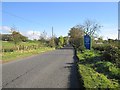
Longland Road
A local authority boundary on the B49.
Image: © Richard Webb
Taken: 21 Oct 2012
0.17 miles
2
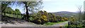
Eglish Mountain
Looking to the north-east.
Image: © Kenneth Allen
Taken: 1 May 2007
0.24 miles
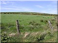
3
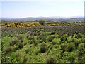
Eglish Mountain
The view through that gate.
Image: © Kenneth Allen
Taken: 1 May 2007
0.24 miles
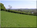
4
Upper Alla Townland
Eglish is to the west.
Image: © Kenneth Allen
Taken: 1 May 2007
0.25 miles
5
Upper Alla
Claudy village lies to the north-west of here.
Image: © Kenneth Allen
Taken: 1 May 2007
0.25 miles