IMAGES TAKEN NEAR TO
Berryhill Road, STRABANE, BT82 0JP
Introduction
This page details the photographs taken nearby to Berryhill Road, BT82 0JP by members of the Geograph project.
The Geograph project started in 2005 with the aim of publishing, organising and preserving representative images for every square kilometre of Great Britain, Ireland and the Isle of Man.

There are currently over 7.5m images from over14,400 individuals and you can help contribute to the project by visiting https://www.geograph.org.uk
Image Map
Images are licensed for reuse under creativecommons.org/licenses/by-sa/2.0
Notes
- Clicking on the map will re-center to the selected point.
- The higher the marker number, the further away the image location is from the centre of the postcode.
Image Listing (3 Images Found)
Images are licensed for reuse under creativecommons.org/licenses/by-sa/2.0
Image
Details
Distance
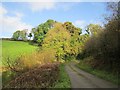
2
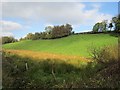
Wetland off Berryhill Road
North of the B49, a damp hollow.
Image: © Richard Webb
Taken: 21 Oct 2012
0.12 miles
3
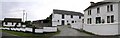
Farm Buildings at Windyhill
It is good to see that the original old farm building in the centre has been preserved, even though the dwellings have been renovated.
Image: © Kenneth Allen
Taken: 20 Jul 2006
0.22 miles