IMAGES TAKEN NEAR TO
Hollyhill Road, STRABANE, BT82 0GA
Introduction
This page details the photographs taken nearby to Hollyhill Road, BT82 0GA by members of the Geograph project.
The Geograph project started in 2005 with the aim of publishing, organising and preserving representative images for every square kilometre of Great Britain, Ireland and the Isle of Man.

There are currently over 7.5m images from over14,400 individuals and you can help contribute to the project by visiting https://www.geograph.org.uk
Image Map
Images are licensed for reuse under creativecommons.org/licenses/by-sa/2.0
Notes
- Clicking on the map will re-center to the selected point.
- The higher the marker number, the further away the image location is from the centre of the postcode.
Image Listing (11 Images Found)
Images are licensed for reuse under creativecommons.org/licenses/by-sa/2.0
Image
Details
Distance
1
Ballymagorry, County Tyrone
Heading south-west towards Strabane
Image: © Kenneth Allen
Taken: 5 Nov 2008
0.08 miles
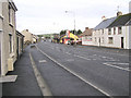
2
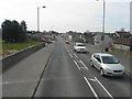
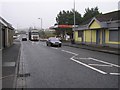
Victoria Road, Ballymagorry
Heading towards Strabane
Image: © Kenneth Allen
Taken: 9 Apr 2010
0.08 miles
3
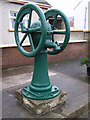
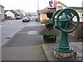
Pump, Ballymagorry
It is located along the main road
Image: © Kenneth Allen
Taken: 5 Nov 2008
0.09 miles
4
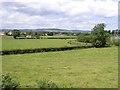
Ballymagorry Townland
Looking north-west
Image: © Kenneth Allen
Taken: 27 Jun 2006
0.13 miles
5
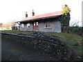
Ballymagorry Railway Station
It is still standing along the remaining section of platform - better buildings than this have long since vanished. It was the stop for the narrow gauge track that came from Strabane to Derry / Londonderry line and further along there was a station which served the small village of Donemana, although it was several miles away and bore the name.
Both stations opened in August 1900 and closed on 1st January, 1955.
Image: © Kenneth Allen
Taken: 11 Jan 2011
0.14 miles
6
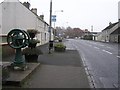
Ballymagorry, County Tyrone
A view looking northwards, there is a cast iron pump with a circular wheel, at the footpath, just before Floyd's restaurant on the right hand side.
Image: © Kenneth Allen
Taken: 21 Dec 2005
0.14 miles
7
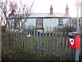
Rear of Ballymagorry Railway Station
The view from Railway Road towards this tin-clad building
Image: © Kenneth Allen
Taken: 11 Jan 2011
0.15 miles
8
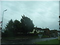
Joining the A5 from Woodend Road at Ballymaggory
Ballymagorry, (pop 565), is the southernmost of a string of contiguous settlements on the east bank of the Foyle between Strabane and Londonderry/Derry with a Loyalist majority (54-44% in the case of Ballymagorry). This compares with the 6% Loyalist and 93% Nationalist population composition of the town of Strabane.
Image: © Eric Jones
Taken: 19 Aug 2009
0.15 miles
9
Floyd's Restaurant, Ballymagorry
It is located along the Victoria Road
Image: © Kenneth Allen
Taken: 5 Nov 2008
0.18 miles
10
Victoria Road, Ballymagorry
Heading north-east towards Derry / Londonderry
Image: © Kenneth Allen
Taken: 5 Nov 2008
0.19 miles