IMAGES TAKEN NEAR TO
Trienamongan Road, CASTLEDERG, BT81 7XF
Introduction
This page details the photographs taken nearby to Trienamongan Road, BT81 7XF by members of the Geograph project.
The Geograph project started in 2005 with the aim of publishing, organising and preserving representative images for every square kilometre of Great Britain, Ireland and the Isle of Man.

There are currently over 7.5m images from over14,400 individuals and you can help contribute to the project by visiting https://www.geograph.org.uk
Image Map
Images are licensed for reuse under creativecommons.org/licenses/by-sa/2.0
Notes
- Clicking on the map will re-center to the selected point.
- The higher the marker number, the further away the image location is from the centre of the postcode.
Image Listing (6 Images Found)
Images are licensed for reuse under creativecommons.org/licenses/by-sa/2.0
Image
Details
Distance
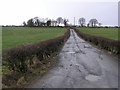
1

Carracoghan Townland
Looking east from the Trienamongan Road towards Mullanabreety Hill
Image: © Kenneth Allen
Taken: 11 Mar 2008
0.05 miles
2
Carracoghan Townland
Looking northwards
Image: © Kenneth Allen
Taken: 11 Mar 2008
0.08 miles
3
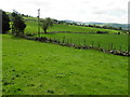
Trienamongan Townland
Looking SSE from Trienamongan Road
Image: © Kenneth Allen
Taken: 27 May 2014
0.16 miles
4
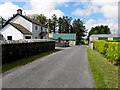
Cashel Cottages, Trienamongan
Pictured along Trienamongan Road
Image: © Kenneth Allen
Taken: 27 May 2014
0.22 miles
5
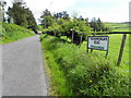
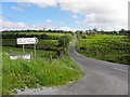
Trienamongan Road, Trienamongan
Heading ENE - how convenient for the Roads Service to place roadsign names with townlands through the county!
The only exception to this in Northern Ireland is County Fermanagh
Maybe with Omagh and Fermanagh councils merging next year there might be a change of thought.
Image: © Kenneth Allen
Taken: 27 May 2014
0.23 miles
6
Trienamongan Road, Aghyaran
Heading NNE from Corgary Road
Image: © Kenneth Allen
Taken: 27 May 2014
0.24 miles