IMAGES TAKEN NEAR TO
Killeter Road, CASTLEDERG, BT81 7TW
Introduction
This page details the photographs taken nearby to Killeter Road, BT81 7TW by members of the Geograph project.
The Geograph project started in 2005 with the aim of publishing, organising and preserving representative images for every square kilometre of Great Britain, Ireland and the Isle of Man.

There are currently over 7.5m images from over14,400 individuals and you can help contribute to the project by visiting https://www.geograph.org.uk
Image Map
Images are licensed for reuse under creativecommons.org/licenses/by-sa/2.0
Notes
- Clicking on the map will re-center to the selected point.
- The higher the marker number, the further away the image location is from the centre of the postcode.
Image Listing (27 Images Found)
Images are licensed for reuse under creativecommons.org/licenses/by-sa/2.0
Image
Details
Distance
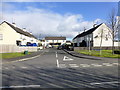
1
Millbrook Gardens, Castlederg
Heading north from Killeter Road
Image: © Kenneth Allen
Taken: 5 Apr 2016
0.07 miles
2
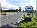
Welcome to Castlederg
Approaching Castlederg from the west
Image: © Kenneth Allen
Taken: 5 Apr 2016
0.08 miles
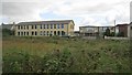
3
Former school, Castlederg
It was St Brigid's High School
Pictured along Cavan Road
Image: © Kenneth Allen
Taken: 5 Apr 2016
0.10 miles
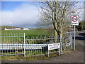
4
Alexander Park, Castlederg
Pictured along Killeter Road
Image: © Kenneth Allen
Taken: 5 Apr 2016
0.11 miles
5
St Eugene's High School, Castlederg
Approaching the town from the west.
Image: © Richard Webb
Taken: 20 Jul 2012
0.11 miles
6
Killeter Road, Kilcroagh
Heading east
Ahead to the left is Image]
Image: © Kenneth Allen
Taken: 3 Sep 2014
0.11 miles
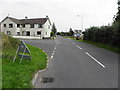
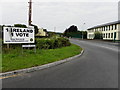
7
Killeter Road
Heading west from Castlederg
Image: © Kenneth Allen
Taken: 5 Apr 2016
0.12 miles
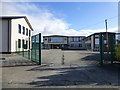
8
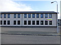
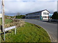
Gateway Enterprise Complex, Castlederg
Located along Cavan Road, it was a High School
Image: © Kenneth Allen
Taken: 5 Apr 2016
0.12 miles
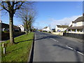
9
Cavan Road, Castlederg
Heading north-west from Killeter Road
The building on the right is a former school
Image: © Kenneth Allen
Taken: 5 Apr 2016
0.12 miles
10
Cavan Road, Kilcroagh
Heading north-west from Killeter Road
St Eugene's High School is on the right, it is now closed, with most of the pupils travelling to the new school in Strabane
For a while it was used by the pupils of the small special needs school at Arvalee which was destroyed by arson.
Image: © Kenneth Allen
Taken: 3 Sep 2014
0.14 miles