IMAGES TAKEN NEAR TO
Speer Park, CASTLEDERG, BT81 7RP
Introduction
This page details the photographs taken nearby to Speer Park, BT81 7RP by members of the Geograph project.
The Geograph project started in 2005 with the aim of publishing, organising and preserving representative images for every square kilometre of Great Britain, Ireland and the Isle of Man.

There are currently over 7.5m images from over14,400 individuals and you can help contribute to the project by visiting https://www.geograph.org.uk
Image Map
Images are licensed for reuse under creativecommons.org/licenses/by-sa/2.0
Notes
- Clicking on the map will re-center to the selected point.
- The higher the marker number, the further away the image location is from the centre of the postcode.
Image Listing (13 Images Found)
Images are licensed for reuse under creativecommons.org/licenses/by-sa/2.0
Image
Details
Distance
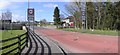
1
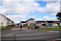
Killen Park, Killen Village
Located along Main Street
Image: © Kenneth Allen
Taken: 21 May 2019
0.11 miles
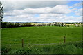
2
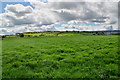
Green fields, Killen Near
Looking south-east
Image: © Kenneth Allen
Taken: 21 May 2019
0.14 miles
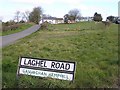
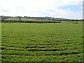
3
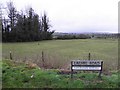
Ganvaghan Hemphill
Looking west from Laghel Road
Image: © Kenneth Allen
Taken: 7 Jan 2014
0.18 miles
4
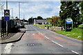
Bridge along Scraghy Road
Heading SSW from Gavaghan Hemphill to Killen Near and Village
Image: © Kenneth Allen
Taken: 21 May 2019
0.19 miles
5
Welcome to Killen
Please drive carefully!
Image: © Kenneth Allen
Taken: 5 Apr 2007
0.20 miles
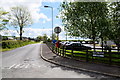
6
Laghel Road
It is in the townland of Ganvaghan Hemphill
Image: © Kenneth Allen
Taken: 5 Apr 2007
0.20 miles
7
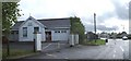
Killen Primary School
Built in 1935 and closed in 2007. Shortly this building is to be demolished as the pupils occupy a new school on the same site.
Image: © Kenneth Allen
Taken: 6 May 2007
0.20 miles
8
Munie Road, Munie
Heading ESE from Scraghy Road
Image: © Kenneth Allen
Taken: 21 May 2019
0.22 miles
9
Munie, Killen
Bin Mountain is in the distance.
Image: © Kenneth Allen
Taken: 5 Apr 2007
0.22 miles
10
Gavaghan Hemphill Townland
Looking north-west from Srcraghy Road
Image: © Kenneth Allen
Taken: 21 May 2019
0.23 miles