IMAGES TAKEN NEAR TO
Mill Avenue, CASTLEDERG, BT81 7NB
Introduction
This page details the photographs taken nearby to Mill Avenue, BT81 7NB by members of the Geograph project.
The Geograph project started in 2005 with the aim of publishing, organising and preserving representative images for every square kilometre of Great Britain, Ireland and the Isle of Man.

There are currently over 7.5m images from over14,400 individuals and you can help contribute to the project by visiting https://www.geograph.org.uk
Image Map
Images are licensed for reuse under creativecommons.org/licenses/by-sa/2.0
Notes
- Clicking on the map will re-center to the selected point.
- The higher the marker number, the further away the image location is from the centre of the postcode.
Image Listing (6 Images Found)
Images are licensed for reuse under creativecommons.org/licenses/by-sa/2.0
Image
Details
Distance
1
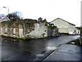
Ruined building, Spamount
Behind is Spamount & District Cross-Community Hall, opposite Millbrae Court
Image: © Kenneth Allen
Taken: 4 Nov 2014
0.05 miles
2
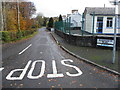
Scarvaherin Road, Spamount
Heading north-east from Drumnabey Road
Image: © Kenneth Allen
Taken: 4 Nov 2014
0.21 miles
3
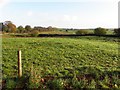
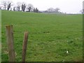
Drumnabey Townland
Looking north-east near Spamount
Image: © Kenneth Allen
Taken: 12 Nov 2013
0.21 miles
4
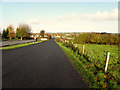
Heading towards Spamount
Going north-west on Drumnabey Road
Image: © Kenneth Allen
Taken: 12 Nov 2013
0.23 miles
5
Spamount, Castlederg
Looking westwards.
Image: © Kenneth Allen
Taken: 27 Mar 2007
0.24 miles
6
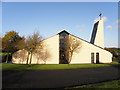
St Francis RC Church (side-view)
The shadows of the trees are nicely reflected onto the walls of the church
Image: © Kenneth Allen
Taken: 12 Nov 2013
0.25 miles