IMAGES TAKEN NEAR TO
Craigmonaghan Lane, CASTLEDERG, BT81 7LW
Introduction
This page details the photographs taken nearby to Craigmonaghan Lane, BT81 7LW by members of the Geograph project.
The Geograph project started in 2005 with the aim of publishing, organising and preserving representative images for every square kilometre of Great Britain, Ireland and the Isle of Man.

There are currently over 7.5m images from over14,400 individuals and you can help contribute to the project by visiting https://www.geograph.org.uk
Image Map
Images are licensed for reuse under creativecommons.org/licenses/by-sa/2.0
Notes
- Clicking on the map will re-center to the selected point.
- The higher the marker number, the further away the image location is from the centre of the postcode.
Image Listing (11 Images Found)
Images are licensed for reuse under creativecommons.org/licenses/by-sa/2.0
Image
Details
Distance
1
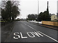
Strabane Road, Craigmonaghan (Nelson)
Heading WSW towards Castlederg
Image: © Kenneth Allen
Taken: 3 Dec 2014
0.08 miles
2
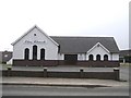
Elim Church, Castlederg
It is to the east of the town.
Image: © Kenneth Allen
Taken: 27 Mar 2007
0.08 miles
3

Strabane Road, Churchtown / Mount Bernard
Heading ENE towards Craigmonaghan (Nelson)
Image: © Kenneth Allen
Taken: 20 Feb 2019
0.08 miles
4

Strabane Road Craigmonaghan (Funston) / Mount Bernard
Heading ENE
Image: © Kenneth Allen
Taken: 20 Feb 2019
0.09 miles
5
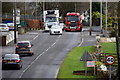
B72 Strabane Road
A busy road heading ENE from Castlederg towards Victoria Bridge
Image: © Kenneth Allen
Taken: 20 Feb 2019
0.11 miles
6

Sheep, Mount Bernard, Castlederg
Pictured along Strabane Road
Image: © Kenneth Allen
Taken: 20 Feb 2019
0.12 miles
7
Churchtown, Castlederg
Pictured along Strabane Road
Image: © Kenneth Allen
Taken: 20 Feb 2019
0.17 miles
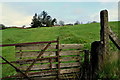
8

Craigmonaghan (Funston) Townland
Pictured along Strabane Road
Image: © Kenneth Allen
Taken: 20 Feb 2019
0.19 miles
9

Tree and shadow, Mount Bernard
Pictured along Fyfin Road / Strabane Road
Image: © Kenneth Allen
Taken: 20 Feb 2019
0.21 miles
10

Strabane Road Mount Bernard / Craigmonaghan (Funston)
Heading west towards Castlederg
Image: © Kenneth Allen
Taken: 20 Feb 2019
0.21 miles