IMAGES TAKEN NEAR TO
Meenamullin Road, CASTLEDERG, BT81 7HQ
Introduction
This page details the photographs taken nearby to Meenamullin Road, BT81 7HQ by members of the Geograph project.
The Geograph project started in 2005 with the aim of publishing, organising and preserving representative images for every square kilometre of Great Britain, Ireland and the Isle of Man.

There are currently over 7.5m images from over14,400 individuals and you can help contribute to the project by visiting https://www.geograph.org.uk
Image Map
Images are licensed for reuse under creativecommons.org/licenses/by-sa/2.0
Notes
- Clicking on the map will re-center to the selected point.
- The higher the marker number, the further away the image location is from the centre of the postcode.
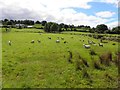
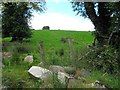
Image Listing (6 Images Found)
Images are licensed for reuse under creativecommons.org/licenses/by-sa/2.0
Image
Details
Distance
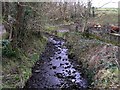
3
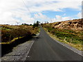
Meenamullan Road, Killeter
Heading SSW towards Meenamullan
Image: © Kenneth Allen
Taken: 7 Apr 2014
0.17 miles
5
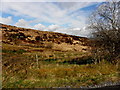
Mellon's Glen
This historic area is located to the west of Killeter.
Image: © Kenneth Allen
Taken: 20 Feb 2008
0.20 miles
6
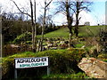
Aghalougher sign
They forgot to add "Rd" to the road name
Behind is Mellon's Glen
Image: © Kenneth Allen
Taken: 7 Apr 2014
0.24 miles