IMAGES TAKEN NEAR TO
Ferguson Crescent, CASTLEDERG, BT81 7AF
Introduction
This page details the photographs taken nearby to Ferguson Crescent, BT81 7AF by members of the Geograph project.
The Geograph project started in 2005 with the aim of publishing, organising and preserving representative images for every square kilometre of Great Britain, Ireland and the Isle of Man.

There are currently over 7.5m images from over14,400 individuals and you can help contribute to the project by visiting https://www.geograph.org.uk
Image Map
Images are licensed for reuse under creativecommons.org/licenses/by-sa/2.0
Notes
- Clicking on the map will re-center to the selected point.
- The higher the marker number, the further away the image location is from the centre of the postcode.
Image Listing (527 Images Found)
Images are licensed for reuse under creativecommons.org/licenses/by-sa/2.0
Image
Details
Distance
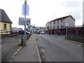
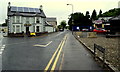
1
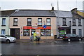
Today's Local, Castlederg
Pictured at the end of Main Street
Image: © Kenneth Allen
Taken: 31 Jul 2018
0.00 miles
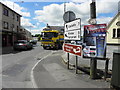
3
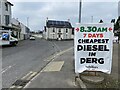
NEW
Cheapest diesel notice, Castlederg
I forgot to find out the price.
Image: © Kenneth Allen
Taken: 10 Mar 2025
0.00 miles
5
Kilclean Road, Castlederg
Heading south-east
Image: © Kenneth Allen
Taken: 5 Apr 2016
0.01 miles
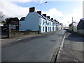
6
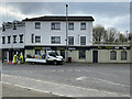
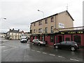
NEW
Forge Bistro, Castlederg
Pictured at Ferguson Crescent
Image: © Kenneth Allen
Taken: 10 Mar 2025
0.01 miles
7
Killeter Road, Castlederg
Heading WNW from the town
Image: © Kenneth Allen
Taken: 16 Jun 2014
0.01 miles
8
Killeter Road, Castlederg
Heading west from the Diamond area
Image: © Kenneth Allen
Taken: 5 Apr 2016
0.01 miles
9
Kilclean Road, Castlederg
Heading north-west
Image: © Kenneth Allen
Taken: 31 Jul 2018
0.01 miles
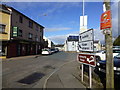
10
Killeter Road, Castlederg
Heading east
Image: © Kenneth Allen
Taken: 5 Apr 2016
0.01 miles