IMAGES TAKEN NEAR TO
Ramper Road, COOKSTOWN, BT80 9TB
Introduction
This page details the photographs taken nearby to Ramper Road, BT80 9TB by members of the Geograph project.
The Geograph project started in 2005 with the aim of publishing, organising and preserving representative images for every square kilometre of Great Britain, Ireland and the Isle of Man.

There are currently over 7.5m images from over14,400 individuals and you can help contribute to the project by visiting https://www.geograph.org.uk
Image Map
Images are licensed for reuse under creativecommons.org/licenses/by-sa/2.0
Notes
- Clicking on the map will re-center to the selected point.
- The higher the marker number, the further away the image location is from the centre of the postcode.
Image Listing (4 Images Found)
Images are licensed for reuse under creativecommons.org/licenses/by-sa/2.0
Image
Details
Distance
1
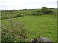
Ballynagilly Townland
Looking northwards
Image: © Kenneth Allen
Taken: 31 Jul 2007
0.15 miles
2
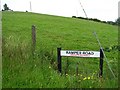
Ramper Road
It is in the townland of Ballynagilly
Image: © Kenneth Allen
Taken: 31 Jul 2007
0.17 miles
3
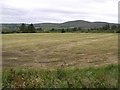
Near Davagh Forest
Looking away from the tree area.
Image: © Kenneth Allen
Taken: 31 Jul 2007
0.17 miles
4
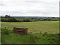
Davagh
Looks like some sort of animal feeder in the field.
Image: © Kenneth Allen
Taken: 31 Jul 2007
0.23 miles