IMAGES TAKEN NEAR TO
Cavanoneill Road, COOKSTOWN, BT80 9EW
Introduction
This page details the photographs taken nearby to Cavanoneill Road, BT80 9EW by members of the Geograph project.
The Geograph project started in 2005 with the aim of publishing, organising and preserving representative images for every square kilometre of Great Britain, Ireland and the Isle of Man.

There are currently over 7.5m images from over14,400 individuals and you can help contribute to the project by visiting https://www.geograph.org.uk
Image Map
Images are licensed for reuse under creativecommons.org/licenses/by-sa/2.0
Notes
- Clicking on the map will re-center to the selected point.
- The higher the marker number, the further away the image location is from the centre of the postcode.
Image Listing (3 Images Found)
Images are licensed for reuse under creativecommons.org/licenses/by-sa/2.0
Image
Details
Distance
1
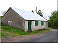
Hall at Cloghfin
It seems to be well secured.
Image: © Kenneth Allen
Taken: 26 May 2006
0.03 miles
2
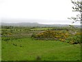
Cloghfin Townland
The view is to the north
Image: © Kenneth Allen
Taken: 26 May 2006
0.03 miles
3
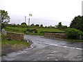
Bridge at Cloghfin, Pomeroy
It spans the burn which makes its way to Wellbrook Beetling Mill. It is not un-common to see flags from either side of the community placed at various locations - see http://www.geograph.org.uk/photo/176539#form
Image: © Kenneth Allen
Taken: 26 May 2006
0.20 miles