IMAGES TAKEN NEAR TO
Drum Road, COOKSTOWN, BT80 8JQ
Introduction
This page details the photographs taken nearby to Drum Road, BT80 8JQ by members of the Geograph project.
The Geograph project started in 2005 with the aim of publishing, organising and preserving representative images for every square kilometre of Great Britain, Ireland and the Isle of Man.

There are currently over 7.5m images from over14,400 individuals and you can help contribute to the project by visiting https://www.geograph.org.uk
Image Map
Images are licensed for reuse under creativecommons.org/licenses/by-sa/2.0
Notes
- Clicking on the map will re-center to the selected point.
- The higher the marker number, the further away the image location is from the centre of the postcode.
Image Listing (6 Images Found)
Images are licensed for reuse under creativecommons.org/licenses/by-sa/2.0
Image
Details
Distance
1
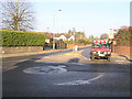
Westland Road, Cookstown
One of a pair of mini-roundabouts which require careful negotiating.
Image: © Kenneth Allen
Taken: 29 Jan 2006
0.03 miles
2
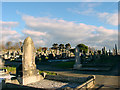
Forthill Cemetery, Cookstown
The cemetery for Cookstown. I have found a suggestion on the internet that Forthill was named after a nearby "rath".
Image: © Linda Bailey
Taken: 2 Mar 2005
0.19 miles
3
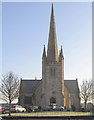
St Luran's Parish Church, Cookstown
It is on the main road, opposite the junction with the Omagh Road.
Image: © Kenneth Allen
Taken: 29 Jan 2006
0.22 miles
4
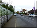
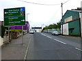
Drum Road, Cookstown
Heading west from Killymoon Street / Church Street
Note the virtual wall on the left
Image: © Kenneth Allen
Taken: 24 Oct 2018
0.22 miles
5
A505 Drum Road, Cookstown
Heading east to Church Street and Killymoon Street
Image: © Kenneth Allen
Taken: 24 Oct 2018
0.23 miles
6
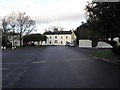
Greenvale Hotel, Cookstown
It is located in its own grounds on the Omagh side of the town
Image: © Kenneth Allen
Taken: 16 Dec 2009
0.25 miles