IMAGES TAKEN NEAR TO
Rathbeg, COOKSTOWN, BT80 8HR

Introduction

This page details the photographs taken nearby to Rathbeg, BT80 8HR by members of the Geograph project.

The Geograph project started in 2005 with the aim of publishing, organising and preserving representative images for every square kilometre of Great Britain, Ireland and the Isle of Man.

There are currently over 7.5m images from over14,400 individuals and you can help contribute to the project by visiting https://www.geograph.org.uk

Image Map


Images are licensed for reuse under creativecommons.org/licenses/by-sa/2.0
Notes
  • Clicking on the map will re-center to the selected point.
  • The higher the marker number, the further away the image location is from the centre of the postcode.

Image Listing (33 Images Found)

Images are licensed for reuse under creativecommons.org/licenses/by-sa/2.0
  • ...
Image
Details
Distance
1
Chapel Street Service Station, Cookstown
It is located along Chapel Street
Image: © Kenneth Allen Taken: 16 Dec 2009
0.11 miles
2
Partytown / Tasty Bites, Cookstown
They are located at Chapel Street
Image: © Kenneth Allen Taken: 16 Dec 2009
0.11 miles
3
RC Church of the Most Holy Trinity, Cookstown
Shrouded in protective mesh whilst repairs are being carried out, it makes the spire more visible as you approach the town
Image: © Kenneth Allen Taken: 16 Dec 2009
0.11 miles
4
Swish Windows, Cookstown
It is located at Chapel Street
Image: © Kenneth Allen Taken: 16 Dec 2009
0.11 miles
5
Holy Trinity College, Cookstown
It is located at Chapel Street
Image: © Kenneth Allen Taken: 16 Dec 2009
0.12 miles
6
Irish National Foresters / Golden Boat, Cookstown
INF halls in Ireland are hard to find now, though Orange Halls are plenty in the north part of the country, by that I mean Northern Ireland and in the Irish Republic round border areas
Image: © Kenneth Allen Taken: 16 Dec 2009
0.12 miles
7
Church of the Most Holy Trinity, Cookstown
The church dates from 1860.
Image: © Linda Bailey Taken: 14 Aug 2002
0.13 miles
8
Church of the Most Holy Trinity, Cookstown
Rear view of the Church of the Most Holy Trinity, Cookstown. See Image for a view from the front. There is a flush bracket bench mark on the rear wall - see Image
Image: © Rossographer Taken: 12 Jun 2014
0.13 miles
9
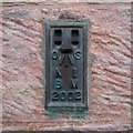
Flush Bracket, Cookstown
Flush bracket bench mark on the rear wall of the Church of the Most Holy Trinity, Cookstown - see Image & Image The number on the bracket is OSNIBM 2002. The mark has been levelled to 75.55 metres above MSL. A note on brackets numbered OSNIBM 2001-2055: all of these are located in County Tyrone and were sited when the county was surveyed in the mid 1930s. At this time counties in Ulster were surveyed individually (with Belfast also subject to its own survey). The plan appeared to be to survey Tyrone (which was completed) and then move onto Armagh, however the Second World War intervened and the latter never happened (they only got as far as establishing 4 flush brackets numbered 2097-2100 in Armagh city and Portadown). After the war ended plans changed and Northern Ireland was surveyed in its entirety for the first time in the 1950s - many of these early flush brackets were reused for that survey (this one was included in the primary line between Magherafelt and Armagh) but some in very obscure locations were never used again. OSNIBM 2001 was located on a primary school in Cookstown but this, like a few others, has been destroyed.
Image: © Rossographer Taken: 12 Jun 2014
0.13 miles
10
6th Tyrone Scouts, Cookstown
It is located beside the College at Chapel Street
Image: © Kenneth Allen Taken: 16 Dec 2009
0.13 miles
  • ...