IMAGES TAKEN NEAR TO
Drumnakilly Road, OMAGH, BT79 9PU
Introduction
This page details the photographs taken nearby to Drumnakilly Road, BT79 9PU by members of the Geograph project.
The Geograph project started in 2005 with the aim of publishing, organising and preserving representative images for every square kilometre of Great Britain, Ireland and the Isle of Man.

There are currently over 7.5m images from over14,400 individuals and you can help contribute to the project by visiting https://www.geograph.org.uk
Image Map
Images are licensed for reuse under creativecommons.org/licenses/by-sa/2.0
Notes
- Clicking on the map will re-center to the selected point.
- The higher the marker number, the further away the image location is from the centre of the postcode.
Image Listing (8 Images Found)
Images are licensed for reuse under creativecommons.org/licenses/by-sa/2.0
Image
Details
Distance
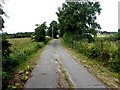
1
Minor road at Clare
Heading NNW from Drumnakilly
The middle section down-grades to a rough lane
Image: © Kenneth Allen
Taken: 13 Jul 2013
0.03 miles
2
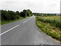
Drumnakilly Road, Carrickmore
Heading east towards Carrickmore village from Carrickmore Townland
(The townlands of Clare and Aghnagreggan are in between)
Image: © Kenneth Allen
Taken: 13 Jul 2013
0.06 miles
3
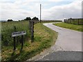
Minnadinna Lane, Carrickmore
Heading south from Drumnakilly Road
Image: © Kenneth Allen
Taken: 13 Jul 2013
0.07 miles
4
Concrete lane, Clare
Heading NNW - there are cracks in places
Image: © Kenneth Allen
Taken: 13 Jul 2013
0.16 miles
5
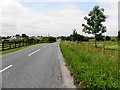
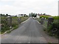
B4 Drumnakilly Road, Clare
Heading west towards Omagh
Image: © Kenneth Allen
Taken: 13 Jul 2013
0.21 miles
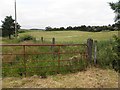
8
Clare Townland
Looking north from Drumnakilly Road
Image: © Kenneth Allen
Taken: 13 Jul 2013
0.23 miles