IMAGES TAKEN NEAR TO
Drumnakilly Road, OMAGH, BT79 9PN
Introduction
This page details the photographs taken nearby to Drumnakilly Road, BT79 9PN by members of the Geograph project.
The Geograph project started in 2005 with the aim of publishing, organising and preserving representative images for every square kilometre of Great Britain, Ireland and the Isle of Man.

There are currently over 7.5m images from over14,400 individuals and you can help contribute to the project by visiting https://www.geograph.org.uk
Image Map
Images are licensed for reuse under creativecommons.org/licenses/by-sa/2.0
Notes
- Clicking on the map will re-center to the selected point.
- The higher the marker number, the further away the image location is from the centre of the postcode.
Image Listing (7 Images Found)
Images are licensed for reuse under creativecommons.org/licenses/by-sa/2.0
Image
Details
Distance
1

Bracky Townland
Sometimes you can see a bright reflection in the distance, possibly from the sun shining at an angle on a glass surface.
Image: © Kenneth Allen
Taken: 4 May 2008
0.03 miles
2
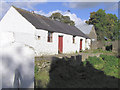
Farm building
Old farm building in the townland of Magurgan, which may originally have been a dwelling house.
Image: © Kenneth Allen
Taken: 13 Oct 2005
0.05 miles
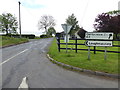
3
Hidden road sign, Mullaghslin Glebe
Pictured along here Image]
Image: © Kenneth Allen
Taken: 30 May 2017
0.21 miles
4
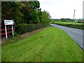
B4 Drumnakilly Road, Mullaghslin Glebe
Heading west towards Omagh
Image: © Kenneth Allen
Taken: 30 May 2017
0.21 miles
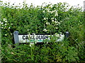
5
Camlough Road
Heading ENE from Drumnakilly Road at Mullaghslin Glebe
Image: © Kenneth Allen
Taken: 30 May 2017
0.25 miles
6
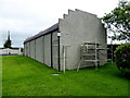
Tracy's Hall, Mullaghslin Glebe (rear view)
A popular local venue about the 1950s
This is a bit like looking at a church, is this the front or back?
In addition to evening socials or dances, the folk used to meet here to play handball against the gable wall on a Sunday afternoon. Such was the numbers that they had to take it in turn to have a game and half the fun was watching the other players.
Image: © Kenneth Allen
Taken: 30 May 2017
0.25 miles
7
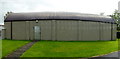
Tracy's Hall, Mullaghslin Glebe (side view)
The corrugated iron roof was masked by the gable walls with their stepped copings Image]
I couldn't get back enough to take the distortion out of this panned image
Image: © Kenneth Allen
Taken: 30 May 2017
0.25 miles