IMAGES TAKEN NEAR TO
Quarry Road, OMAGH, BT79 9JX
Introduction
This page details the photographs taken nearby to Quarry Road, BT79 9JX by members of the Geograph project.
The Geograph project started in 2005 with the aim of publishing, organising and preserving representative images for every square kilometre of Great Britain, Ireland and the Isle of Man.

There are currently over 7.5m images from over14,400 individuals and you can help contribute to the project by visiting https://www.geograph.org.uk
Image Map
Images are licensed for reuse under creativecommons.org/licenses/by-sa/2.0
Notes
- Clicking on the map will re-center to the selected point.
- The higher the marker number, the further away the image location is from the centre of the postcode.
Image Listing (19 Images Found)
Images are licensed for reuse under creativecommons.org/licenses/by-sa/2.0
Image
Details
Distance
1
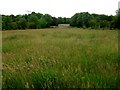
Field with long grass, Carrickmore
Pictured along Quarry Road
Image: © Kenneth Allen
Taken: 16 Jul 2015
0.04 miles
2
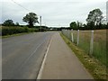
Quarry Road, Carrickmore
Ahead on the left is Image]
Image: © Kenneth Allen
Taken: 16 Jul 2015
0.04 miles
4
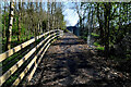
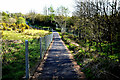
Path along Termon Greenway
Heading NNE towards Image]
Image: © Kenneth Allen
Taken: 21 Apr 2022
0.10 miles
5
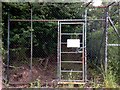
Entrance, Relignaman Women's Graveyard, Carrickmore
The name Relignaman, (Irish - relig na mban), means Women's Graveyard.
It is in a secluded location off the road, 19 metres across and dates from an early Christian period. It was supposed to be sufficiently far from St Colmcille's church in Carrickmore town where the ringing of the bell wouldn't waken the dead. Another tradition decreed that no living woman or no dead man should enter it.
Pictured along Quarry Road
See close-up of notice here Image]
Image: © Kenneth Allen
Taken: 16 Jul 2015
0.11 miles
6
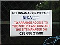
Notice, Relignaman Graveyard
Pictured here Image]
Image: © Kenneth Allen
Taken: 16 Jul 2015
0.11 miles
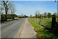
7
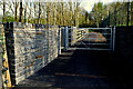
Entrance, Termon Greenway, Carrickmore
This is the access from Quarry Road
It used to be here Image]
Image: © Kenneth Allen
Taken: 21 Apr 2022
0.11 miles
8
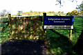
Relignaman Women's Graveyard
The name Relignaman comes from the Irish "relig na mBan", meaning Women's Graveyard. It is a small, sub-rectangular enclosure, c.19m across, surrounded by a grass grown stony bank 1.5-2.5m wide & 0.6-0.9m high
Several accounts surrounding the origin of this site as a graveyard exist in
local tradition. These accounts involve a woman who had somehow incurred
the wrath of St. Colmcille. According to tradition, this spot is where the saint
ordered that she be buried, either out of earshot of the monastery bell or
where the bell being rung in front of her funeral would cease to be heard at St
Colmcille's church. This is the place Colmcille is said to have left an injunction
that the cemetery should never be entered by a living woman or a dead man.
Various other versions of the story can be found in Fr. Short's manuscripts.
Hamlin and Foley, speculating on the origin of Reilig na mBan, remind us that
special provision was sometimes made for the burial of specific groups of
people, including women. One possibility, which they consider, is that this
could mark the site of an early convent, located at a distance from the main
establishment known as Termon Rock. The possibility of a convent at this site
is supported by the fact that it was in a townland called Killeen, possibly
derived from the Irish word, 'cillin' which can mean little church'
and also denote a burial place primarily used for still born and unbaptised infants.
Further support is provided by an Ordnance Survey map, which marks a spot
at Termonmaguirc, as being one of a number of sites or supposed sites of early
women' establishments.
More at https://discovernorthernireland.com/things-to-do/relig-na-mban-p770001
Image: © Kenneth Allen
Taken: 21 Apr 2022
0.12 miles
9

St Colmcille's G.A.A. Club and grounds
It is located to the west of the village
Image: © Kenneth Allen
Taken: 16 May 2006
0.12 miles
10
Path along Termon Greenway
Heading east
Image: © Kenneth Allen
Taken: 21 Apr 2022
0.12 miles