IMAGES TAKEN NEAR TO
Flushtown Road, OMAGH, BT79 9DY
Introduction
This page details the photographs taken nearby to Flushtown Road, BT79 9DY by members of the Geograph project.
The Geograph project started in 2005 with the aim of publishing, organising and preserving representative images for every square kilometre of Great Britain, Ireland and the Isle of Man.

There are currently over 7.5m images from over14,400 individuals and you can help contribute to the project by visiting https://www.geograph.org.uk
Image Map
Images are licensed for reuse under creativecommons.org/licenses/by-sa/2.0
Notes
- Clicking on the map will re-center to the selected point.
- The higher the marker number, the further away the image location is from the centre of the postcode.
Image Listing (46 Images Found)
Images are licensed for reuse under creativecommons.org/licenses/by-sa/2.0
Image
Details
Distance
1
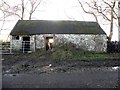
Old farm building,Cloghfin
Pictured along Flushtown Road - I had to kneel down to eliminate the sun's rays striking the camera lens.
Image: © Kenneth Allen
Taken: 21 Nov 2012
0.03 miles
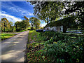
2
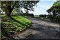
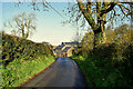
Bend along Flushtown Road
Heading south-west at Cloghfin
Image: © Kenneth Allen
Taken: 14 Oct 2024
0.03 miles
3
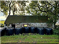
Silage bales along Flushtown Road
Pictured at Cloghfin
Image: © Kenneth Allen
Taken: 14 Oct 2024
0.04 miles
4
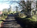
Flushtown Road, Cloghfin
Heading ENE and that winter sun is getting harsher.
Image: © Kenneth Allen
Taken: 21 Nov 2012
0.04 miles
6
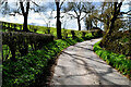
Bend along Flushtown Road
Heading WSW at Cloghfin
Image: © Kenneth Allen
Taken: 2 Apr 2022
0.04 miles
7
Flushtown Road
Proceeding north before a sharp turn to the right.
Image: © Kenneth Allen
Taken: 21 Nov 2012
0.05 miles
8
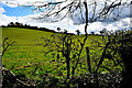
Cloghfin Townland
Looking south from Flushtown Road
Image: © Kenneth Allen
Taken: 2 Apr 2022
0.05 miles
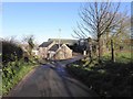
9
Flushtown Road, Cloghfin
Heading north
Image: © Kenneth Allen
Taken: 24 Oct 2020
0.05 miles
10
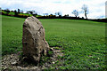
Standing stone, Cloghfin
Located off Flushtown Road
In the Northern Ireland Sites and Monuments website it is described as follows:
On the summit of a low drumlin with higher ground to N, but fine views elsewhere. The stone, which is aligned NE/SW, is a large sandstone slab, standing 1.7m high & rectangular in cross section, measuring 1.6m x 0.7m
Image: © Kenneth Allen
Taken: 2 Apr 2022
0.08 miles