IMAGES TAKEN NEAR TO
Sultan Road, OMAGH, BT79 9AH
Introduction
This page details the photographs taken nearby to Sultan Road, BT79 9AH by members of the Geograph project.
The Geograph project started in 2005 with the aim of publishing, organising and preserving representative images for every square kilometre of Great Britain, Ireland and the Isle of Man.

There are currently over 7.5m images from over14,400 individuals and you can help contribute to the project by visiting https://www.geograph.org.uk
Image Map
Images are licensed for reuse under creativecommons.org/licenses/by-sa/2.0
Notes
- Clicking on the map will re-center to the selected point.
- The higher the marker number, the further away the image location is from the centre of the postcode.
Image Listing (8 Images Found)
Images are licensed for reuse under creativecommons.org/licenses/by-sa/2.0
Image
Details
Distance
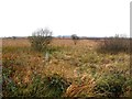
1
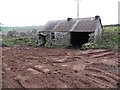
Ruined cottage, Sultan
Viewed along Sultan Road. Interesting to see the sand which is found everywhere in the local quarries round here
Image: © Kenneth Allen
Taken: 3 Dec 2013
0.03 miles
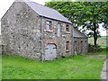
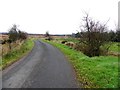
2
Stone cottage at Sultan
Original except for the windows which are PVC.
Image: © Kenneth Allen
Taken: 26 May 2006
0.04 miles
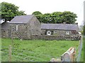
3
Stone buildings at Sultan
They are located beside the stone cottage
Image: © Kenneth Allen
Taken: 26 May 2006
0.04 miles
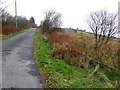
6
Sultan Road, Sultan
Heading north-west
Image: © Kenneth Allen
Taken: 3 Dec 2013
0.18 miles
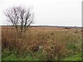
8
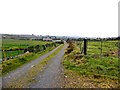
Lane, Sultan
Heading WNW from Sultan Road
Image: © Kenneth Allen
Taken: 3 Dec 2013
0.24 miles