IMAGES TAKEN NEAR TO
Crockanboy Road, OMAGH, BT79 9AF
Introduction
This page details the photographs taken nearby to Crockanboy Road, BT79 9AF by members of the Geograph project.
The Geograph project started in 2005 with the aim of publishing, organising and preserving representative images for every square kilometre of Great Britain, Ireland and the Isle of Man.

There are currently over 7.5m images from over14,400 individuals and you can help contribute to the project by visiting https://www.geograph.org.uk
Image Map
Images are licensed for reuse under creativecommons.org/licenses/by-sa/2.0
Notes
- Clicking on the map will re-center to the selected point.
- The higher the marker number, the further away the image location is from the centre of the postcode.
Image Listing (5 Images Found)
Images are licensed for reuse under creativecommons.org/licenses/by-sa/2.0
Image
Details
Distance
1
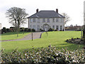
House at Creggan
This is near Creggan crossroads.
Image: © Kenneth Allen
Taken: 25 Jan 2006
0.06 miles
2
A bright sky, Creggan
We haven't seen that for several days!
Image: © Kenneth Allen
Taken: 27 Apr 2013
0.13 miles
3
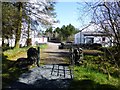
An Creggan Self-catering Cottages
Looking north
Image: © Kenneth Allen
Taken: 27 Apr 2013
0.16 miles
4
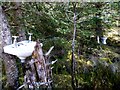
Outside toilet, Creggan
I don't know if this is joke, but there is a wash hand basin and WC placed here
and there isn't any running water or toilet rolls
Image: © Kenneth Allen
Taken: 27 Apr 2013
0.22 miles
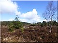
5
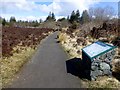
Path, Creggan Centre
Heading north through the bog
Image: © Kenneth Allen
Taken: 27 Apr 2013
0.23 miles