IMAGES TAKEN NEAR TO
Learden Road, OMAGH, BT79 8QD
Introduction
This page details the photographs taken nearby to Learden Road, BT79 8QD by members of the Geograph project.
The Geograph project started in 2005 with the aim of publishing, organising and preserving representative images for every square kilometre of Great Britain, Ireland and the Isle of Man.

There are currently over 7.5m images from over14,400 individuals and you can help contribute to the project by visiting https://www.geograph.org.uk
Image Map
Images are licensed for reuse under creativecommons.org/licenses/by-sa/2.0
Notes
- Clicking on the map will re-center to the selected point.
- The higher the marker number, the further away the image location is from the centre of the postcode.
Image Listing (19 Images Found)
Images are licensed for reuse under creativecommons.org/licenses/by-sa/2.0
Image
Details
Distance
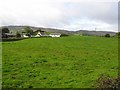
1
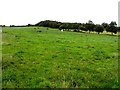
A low hill, Learden Upper
Looking NNE
Image: © Kenneth Allen
Taken: 13 Aug 2013
0.02 miles
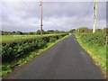
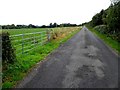
4
Learden Road
Heading ESE towards Culvacullion Road and Gortin
Image: © Kenneth Allen
Taken: 13 Aug 2013
0.04 miles
6
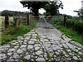
Badly cracked concrete lane, Learden Upper
Pictured along Learden Road
Image: © Kenneth Allen
Taken: 13 Aug 2013
0.06 miles
7
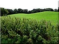
Nettles, Learden Upper
Pictured along Learden Road
Image: © Kenneth Allen
Taken: 13 Aug 2013
0.08 miles
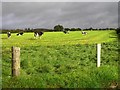
8
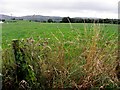
Thistles and long grass, Learden Upper
Pictured along Learden Road
Image: © Kenneth Allen
Taken: 13 Aug 2013
0.09 miles
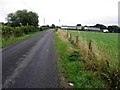
9
Learden Road, Learden Upper
Heading WNW
Image: © Kenneth Allen
Taken: 13 Aug 2013
0.10 miles
10
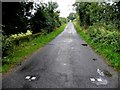
Small bridge along Learden Road
Heading north-west from Culvacullion to Learden Upper
My attention was drawn to these marking blocks on the road Image]
Image: © Kenneth Allen
Taken: 13 Aug 2013
0.11 miles