IMAGES TAKEN NEAR TO
Lenamore Road, OMAGH, BT79 8QA
Introduction
This page details the photographs taken nearby to Lenamore Road, BT79 8QA by members of the Geograph project.
The Geograph project started in 2005 with the aim of publishing, organising and preserving representative images for every square kilometre of Great Britain, Ireland and the Isle of Man.

There are currently over 7.5m images from over14,400 individuals and you can help contribute to the project by visiting https://www.geograph.org.uk
Image Map
Images are licensed for reuse under creativecommons.org/licenses/by-sa/2.0
Notes
- Clicking on the map will re-center to the selected point.
- The higher the marker number, the further away the image location is from the centre of the postcode.
Image Listing (6 Images Found)
Images are licensed for reuse under creativecommons.org/licenses/by-sa/2.0
Image
Details
Distance
3
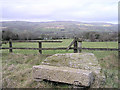
Lenamore Townland
The view is looking north east towards the Sperrins. I just noticed this bench formed out of stones, Fred Flintstone's creation?
Image: © Kenneth Allen
Taken: 18 Feb 2006
0.10 miles
4
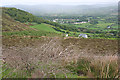
Lenamore
Looking down towards Gortin from the viewpoint above Lenamore.
Image: © Anne Burgess
Taken: 23 May 2014
0.15 miles
5
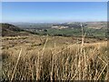
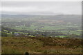
View from Lenamore
Looking NNW in the direction of Gortin village
Image: © Kenneth Allen
Taken: 3 Apr 2021
0.19 miles
6
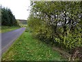
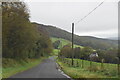
Lenamore Road
Heading WNW to Gortin / Rousky
Image: © Kenneth Allen
Taken: 21 Oct 2010
0.24 miles