IMAGES TAKEN NEAR TO
Woodland Road, OMAGH, BT79 8PS
Introduction
This page details the photographs taken nearby to Woodland Road, BT79 8PS by members of the Geograph project.
The Geograph project started in 2005 with the aim of publishing, organising and preserving representative images for every square kilometre of Great Britain, Ireland and the Isle of Man.

There are currently over 7.5m images from over14,400 individuals and you can help contribute to the project by visiting https://www.geograph.org.uk
Image Map
Images are licensed for reuse under creativecommons.org/licenses/by-sa/2.0
Notes
- Clicking on the map will re-center to the selected point.
- The higher the marker number, the further away the image location is from the centre of the postcode.
Image Listing (23 Images Found)
Images are licensed for reuse under creativecommons.org/licenses/by-sa/2.0
Image
Details
Distance
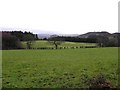
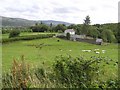
3
Beltrim, near Gortin
The view is looking north towards the Plumbridge area from Woodland Road
Image: © Kenneth Allen
Taken: 20 Feb 2006
0.05 miles
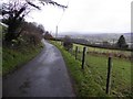
4
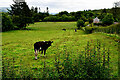
Cattle, Beltrim
Pictured along Woodland Road
Image: © Kenneth Allen
Taken: 11 Jul 2024
0.07 miles
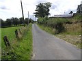
5
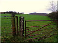
Rylands Townland
Pictured along Woodland Road
Image: © Kenneth Allen
Taken: 24 Nov 2015
0.08 miles
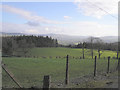
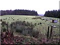
7
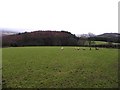
Sheep, Beltrim
Looking ENE in the direction of Gortin
Image: © Kenneth Allen
Taken: 25 Jan 2011
0.12 miles
9
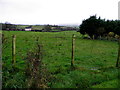
Beltrim Townland
Looking northwards in the direction of Culvahullion
Image: © Kenneth Allen
Taken: 25 Jan 2011
0.14 miles