IMAGES TAKEN NEAR TO
Corrickbeg Road, OMAGH, BT79 8JZ
Introduction
This page details the photographs taken nearby to Corrickbeg Road, BT79 8JZ by members of the Geograph project.
The Geograph project started in 2005 with the aim of publishing, organising and preserving representative images for every square kilometre of Great Britain, Ireland and the Isle of Man.

There are currently over 7.5m images from over14,400 individuals and you can help contribute to the project by visiting https://www.geograph.org.uk
Image Map
Images are licensed for reuse under creativecommons.org/licenses/by-sa/2.0
Notes
- Clicking on the map will re-center to the selected point.
- The higher the marker number, the further away the image location is from the centre of the postcode.
Image Listing (8 Images Found)
Images are licensed for reuse under creativecommons.org/licenses/by-sa/2.0
Image
Details
Distance
1
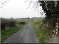
Corrickbeg Road, Learden Lower
Heading west
Image: © Kenneth Allen
Taken: 6 Mar 2013
0.04 miles
2
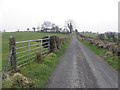
Corrickbeg Road
Heading east at Learden Lower
Image: © Kenneth Allen
Taken: 6 Mar 2013
0.04 miles
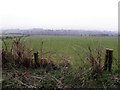
3
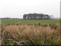
Rushes and trees, Learden Lower
Viewed along Corrickbeg Road
Image: © Kenneth Allen
Taken: 6 Mar 2013
0.05 miles
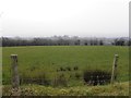
6
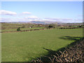
North and South Lislea Townland
A view looking north
Image: © Kenneth Allen
Taken: 25 Feb 2006
0.17 miles
7
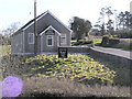
Corrick Gospel Hall
It is located off the road between Newtownstewart and Plumbridge
Image: © Kenneth Allen
Taken: 25 Feb 2006
0.19 miles
8
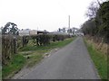
Corrickbeg Road
Heading west- there's a sharp turn to the right up ahead.
Image: © Kenneth Allen
Taken: 6 Mar 2013
0.25 miles