IMAGES TAKEN NEAR TO
Broughderg Road, OMAGH, BT79 8JN
Introduction
This page details the photographs taken nearby to Broughderg Road, BT79 8JN by members of the Geograph project.
The Geograph project started in 2005 with the aim of publishing, organising and preserving representative images for every square kilometre of Great Britain, Ireland and the Isle of Man.

There are currently over 7.5m images from over14,400 individuals and you can help contribute to the project by visiting https://www.geograph.org.uk
Image Map
Images are licensed for reuse under creativecommons.org/licenses/by-sa/2.0
Notes
- Clicking on the map will re-center to the selected point.
- The higher the marker number, the further away the image location is from the centre of the postcode.
Image Listing (4 Images Found)
Images are licensed for reuse under creativecommons.org/licenses/by-sa/2.0
Image
Details
Distance
1
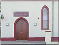
Broughderg Post Office
The sign is in Irish, this is apparently an Irish speaking pocket of the country, as is some parts of Donegal and the south west of Ireland. This post office is located in part of the old church and the rest of the premises has been converted to a youth club.
Image: © Kenneth Allen
Taken: 13 Sep 2005
0.05 miles
2
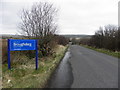
"Welcome to Broughderg" sign
Pictured along Broughderg Road
Image: © Kenneth Allen
Taken: 19 Mar 2014
0.17 miles
3
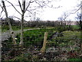
Broughderg Townland
Pictured along Broughderg Road
Image: © Kenneth Allen
Taken: 19 Mar 2014
0.20 miles
4
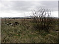
Broughderg Townland
Pictured along Broughderg Road
Image: © Kenneth Allen
Taken: 19 Mar 2014
0.23 miles