IMAGES TAKEN NEAR TO
Landahussy Road, OMAGH, BT79 8EL
Introduction
This page details the photographs taken nearby to Landahussy Road, BT79 8EL by members of the Geograph project.
The Geograph project started in 2005 with the aim of publishing, organising and preserving representative images for every square kilometre of Great Britain, Ireland and the Isle of Man.

There are currently over 7.5m images from over14,400 individuals and you can help contribute to the project by visiting https://www.geograph.org.uk
Image Map
Images are licensed for reuse under creativecommons.org/licenses/by-sa/2.0
Notes
- Clicking on the map will re-center to the selected point.
- The higher the marker number, the further away the image location is from the centre of the postcode.
Image Listing (43 Images Found)
Images are licensed for reuse under creativecommons.org/licenses/by-sa/2.0
Image
Details
Distance
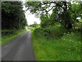
1
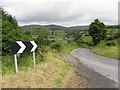
Bend along Landahussy Road
Heading north at Lower Barnes
Image: © Kenneth Allen
Taken: 4 Jul 2013
0.02 miles
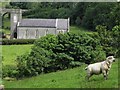
2
Badoney Church of Ireland
Looking NNE from Landahussy Road
Image: © Kenneth Allen
Taken: 4 Jul 2013
0.04 miles
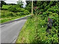
3
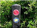
Craignamaddy Circuit post, Upper Drumnaspar
Pictured here Image]
Image: © Kenneth Allen
Taken: 4 Jul 2013
0.04 miles
4
Badoney Church of Ireland (side view)
Looking north-east from Upper Drumnaspar
Image: © Kenneth Allen
Taken: 4 Jul 2013
0.05 miles
5
Landahussy Road, Upper Drumnaspar
Heading south-east
Image: © Kenneth Allen
Taken: 4 Jul 2013
0.06 miles
6
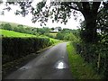
Landahussy Road, Lower Barnes
Heading west
Image: © Kenneth Allen
Taken: 4 Jul 2013
0.07 miles
7
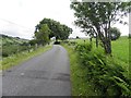
Landahussy Road, Lower Barnes
Heading east
Image: © Kenneth Allen
Taken: 4 Jul 2013
0.09 miles
8
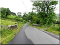
Bridge along Landahussy Road
Heading north-west towards Upper Drumnaspar
Image: © Kenneth Allen
Taken: 4 Jul 2013
0.09 miles
9
Landahussy Road
See close-up of marker post here Image]
Image: © Kenneth Allen
Taken: 4 Jul 2013
0.09 miles
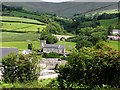
10
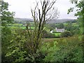
Drumnaspar
Badoney Church is in the distance
Image: © Kenneth Allen
Taken: 5 Sep 2006
0.09 miles