IMAGES TAKEN NEAR TO
Campbell Terrace, OMAGH, BT79 8DJ
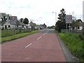
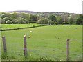
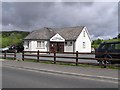
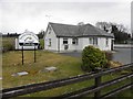
Introduction
This page details the photographs taken nearby to Campbell Terrace, BT79 8DJ by members of the Geograph project.
The Geograph project started in 2005 with the aim of publishing, organising and preserving representative images for every square kilometre of Great Britain, Ireland and the Isle of Man.

There are currently over 7.5m images from over14,400 individuals and you can help contribute to the project by visiting https://www.geograph.org.uk
Image Map
Images are licensed for reuse under creativecommons.org/licenses/by-sa/2.0
Notes
- Clicking on the map will re-center to the selected point.
- The higher the marker number, the further away the image location is from the centre of the postcode.
Image Listing (234 Images Found)
Images are licensed for reuse under creativecommons.org/licenses/by-sa/2.0
Image
Details
Distance
1
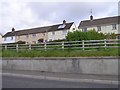
Houses, Plumbridge
Looking north-west
Image: © Kenneth Allen
Taken: 21 May 2009
0.01 miles
2
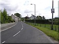
Main Street, Plumbridge
Heading east towards the village centre
Image: © Kenneth Allen
Taken: 21 May 2009
0.02 miles
3
Main Street, Plumbridge
Heading westwards
Image: © Kenneth Allen
Taken: 21 May 2009
0.02 miles
4

Ligford Road
Heading west towards Strabane and Derry / Londonderry
Image: © Kenneth Allen
Taken: 1 Apr 2013
0.03 miles
5
Ligford Road, Plumbridge
Heading east towards the village
Image: © Kenneth Allen
Taken: 22 Mar 2016
0.04 miles
8
Plumbridge Medical Centre
It is located to the west of the village
Image: © Kenneth Allen
Taken: 21 May 2009
0.08 miles
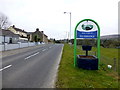
9
Sperrin Family Practice, Plumbridge
Pictured along Ligford Road
Image: © Kenneth Allen
Taken: 1 Apr 2013
0.09 miles
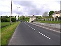
10

Approaching Plumbridge
Heading east along Ligford Road
Image: © Kenneth Allen
Taken: 1 Apr 2013
0.09 miles