IMAGES TAKEN NEAR TO
Pinefield Brae, OMAGH, BT79 7YG
Introduction
This page details the photographs taken nearby to Pinefield Brae, BT79 7YG by members of the Geograph project.
The Geograph project started in 2005 with the aim of publishing, organising and preserving representative images for every square kilometre of Great Britain, Ireland and the Isle of Man.

There are currently over 7.5m images from over14,400 individuals and you can help contribute to the project by visiting https://www.geograph.org.uk
Image Map
Images are licensed for reuse under creativecommons.org/licenses/by-sa/2.0
Notes
- Clicking on the map will re-center to the selected point.
- The higher the marker number, the further away the image location is from the centre of the postcode.
Image Listing (12 Images Found)
Images are licensed for reuse under creativecommons.org/licenses/by-sa/2.0
Image
Details
Distance
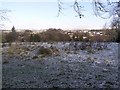
1
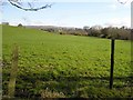
Killclogher Townland
Looking NNE towards the Sperrins
Image: © Kenneth Allen
Taken: 8 Apr 2008
0.11 miles
2
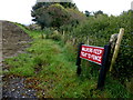
"Walkers keep tight to fence" notice, Killybrack
Pictured along Killyclogher Burn
Image: © Kenneth Allen
Taken: 21 Oct 2016
0.12 miles
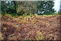
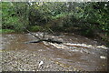
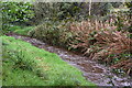
4
Heading along the Killyclogher Burn at Killybrack
This is about far as you can now traverse along this route before encountering closed gates and obstacles.
Image: © Kenneth Allen
Taken: 14 Apr 2008
0.17 miles
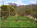
8
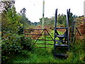
Stile, Mullaghmore
Pictured along Killyclogher Burn
Image: © Kenneth Allen
Taken: 21 Oct 2016
0.21 miles
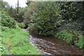
10
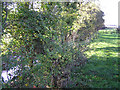
Killyclogher Burn, Killyclogher
Looking towards Omagh
Image: © Kenneth Allen
Taken: 1 Nov 2005
0.22 miles