IMAGES TAKEN NEAR TO
Forest View, OMAGH, BT79 7XS
Introduction
This page details the photographs taken nearby to Forest View, BT79 7XS by members of the Geograph project.
The Geograph project started in 2005 with the aim of publishing, organising and preserving representative images for every square kilometre of Great Britain, Ireland and the Isle of Man.

There are currently over 7.5m images from over14,400 individuals and you can help contribute to the project by visiting https://www.geograph.org.uk
Image Map
Images are licensed for reuse under creativecommons.org/licenses/by-sa/2.0
Notes
- Clicking on the map will re-center to the selected point.
- The higher the marker number, the further away the image location is from the centre of the postcode.
Image Listing (70 Images Found)
Images are licensed for reuse under creativecommons.org/licenses/by-sa/2.0
Image
Details
Distance
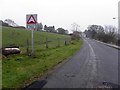
1
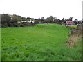
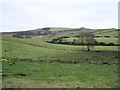
Green field, Mountfield
Looking north-east
Image: © Kenneth Allen
Taken: 27 Sep 2011
0.06 miles
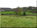
2
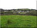
Mountfield, County Tyrone
Looking north-west from Mulnafye
Image: © Kenneth Allen
Taken: 27 Sep 2011
0.10 miles
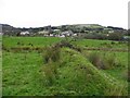
3
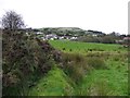
Mulnafye Townland
Looking north in the direction of Mountfield
Image: © Kenneth Allen
Taken: 27 Sep 2011
0.11 miles
4
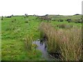
Water and rushes, Mulnafye
Looking north-east
Image: © Kenneth Allen
Taken: 27 Sep 2011
0.11 miles
6
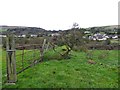
Mulnafye Townland
A view to the north
Image: © Kenneth Allen
Taken: 27 Sep 2011
0.12 miles
7
Mulnafye Townland
Looking NNW in the direction of Mountfield
Image: © Kenneth Allen
Taken: 27 Sep 2011
0.13 miles
8
Raised bank, Mulnafye
Looking north in the direction of Mountfield
Image: © Kenneth Allen
Taken: 27 Sep 2011
0.13 miles
9
Mulnafye Townland
Starting to get dark but the camera can cope!
Image: © Kenneth Allen
Taken: 25 Jan 2006
0.14 miles
10
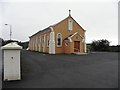
RC Church, Mountfield
It is located along Barony Road
Image: © Kenneth Allen
Taken: 27 Sep 2011
0.15 miles