IMAGES TAKEN NEAR TO
Reaghan Road, OMAGH, BT79 7TG
Introduction
This page details the photographs taken nearby to Reaghan Road, BT79 7TG by members of the Geograph project.
The Geograph project started in 2005 with the aim of publishing, organising and preserving representative images for every square kilometre of Great Britain, Ireland and the Isle of Man.

There are currently over 7.5m images from over14,400 individuals and you can help contribute to the project by visiting https://www.geograph.org.uk
Image Map
Images are licensed for reuse under creativecommons.org/licenses/by-sa/2.0
Notes
- Clicking on the map will re-center to the selected point.
- The higher the marker number, the further away the image location is from the centre of the postcode.
Image Listing (13 Images Found)
Images are licensed for reuse under creativecommons.org/licenses/by-sa/2.0
Image
Details
Distance
1
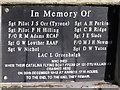
War Memorial Plaque
A close up of the inscription on the war memorial site, near Deer's Leap, between Gortin and Newtownstewart, Co. Tyrone. The word partly shaded is "Killadeas"
Image: © Kenneth Allen
Taken: 6 Dec 2005
0.02 miles
2
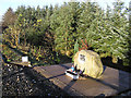
War Memorial near Deer's Leap
It is located half way between Gortin and Newtownstewart, County Tyrone. It refers to a fatal plane crash during WW2
Image: © Kenneth Allen
Taken: 6 Dec 2005
0.05 miles
3
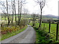
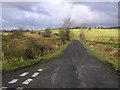
Ballykeel Road, Ballynatubbrit
Heading NNE
Image: © Kenneth Allen
Taken: 16 Apr 2015
0.09 miles
4

Ballykeel Road, Eskeradooey
Heading north-east
Image: © Kenneth Allen
Taken: 16 Apr 2015
0.16 miles
5
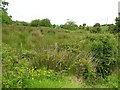
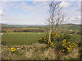
Castleroddy Townland
Plenty of rough land to support wildlife here.
Image: © Kenneth Allen
Taken: 12 Jun 2008
0.17 miles
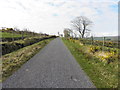
6
Eskeradooey Townland
Looking north-west
Image: © Kenneth Allen
Taken: 16 Apr 2015
0.19 miles
8
Ballykeel Road, Eskeradooey
Heading south-west
Image: © Kenneth Allen
Taken: 16 Apr 2015
0.21 miles
9
Ballykeel Road, Eskeradooey
Heading south-west
Image: © Kenneth Allen
Taken: 16 Apr 2015
0.22 miles
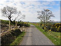
10
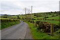
Reaghan Road, Ballynatubbrit
Heading SSE
Image: © Kenneth Allen
Taken: 9 May 2019
0.23 miles