IMAGES TAKEN NEAR TO
Gorticashel Road, OMAGH, BT79 7SB
Introduction
This page details the photographs taken nearby to Gorticashel Road, BT79 7SB by members of the Geograph project.
The Geograph project started in 2005 with the aim of publishing, organising and preserving representative images for every square kilometre of Great Britain, Ireland and the Isle of Man.

There are currently over 7.5m images from over14,400 individuals and you can help contribute to the project by visiting https://www.geograph.org.uk
Image Map
Images are licensed for reuse under creativecommons.org/licenses/by-sa/2.0
Notes
- Clicking on the map will re-center to the selected point.
- The higher the marker number, the further away the image location is from the centre of the postcode.
Image Listing (20 Images Found)
Images are licensed for reuse under creativecommons.org/licenses/by-sa/2.0
Image
Details
Distance
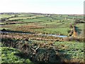
2
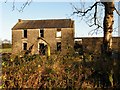
House shell, Carnanfansy
Definitely not turn-key!
Image: © Kenneth Allen
Taken: 10 Nov 2009
0.12 miles
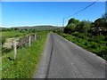
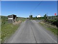
3
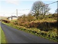
Gorticashel Road
Heading NNW towards Glenhull
Image: © Kenneth Allen
Taken: 10 Nov 2009
0.14 miles
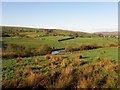
6
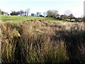
Glenhull Townland
The Owenkillew River is flowing by
Image: © Kenneth Allen
Taken: 10 Nov 2009
0.15 miles
7
Gorticashel Road, Teebane East
Heading north-west
Image: © Kenneth Allen
Taken: 7 Jun 2013
0.16 miles
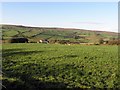
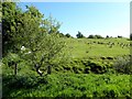
8
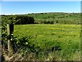
Field with buttercups, Teebane East
Pictured along Gorticashel Road
Image: © Kenneth Allen
Taken: 7 Jun 2013
0.18 miles
9
Gorticashel Road, Teebane East
My attention was drawn to this old structure Image]
Image: © Kenneth Allen
Taken: 7 Jun 2013
0.19 miles
10
Teebane East Townland
Pictured along Gorticashel Road
Image: © Kenneth Allen
Taken: 7 Jun 2013
0.19 miles