IMAGES TAKEN NEAR TO
Greencastle Road, OMAGH, BT79 7RU
Introduction
This page details the photographs taken nearby to Greencastle Road, BT79 7RU by members of the Geograph project.
The Geograph project started in 2005 with the aim of publishing, organising and preserving representative images for every square kilometre of Great Britain, Ireland and the Isle of Man.

There are currently over 7.5m images from over14,400 individuals and you can help contribute to the project by visiting https://www.geograph.org.uk
Image Map
Images are licensed for reuse under creativecommons.org/licenses/by-sa/2.0
Notes
- Clicking on the map will re-center to the selected point.
- The higher the marker number, the further away the image location is from the centre of the postcode.
Image Listing (12 Images Found)
Images are licensed for reuse under creativecommons.org/licenses/by-sa/2.0
Image
Details
Distance
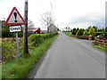
1
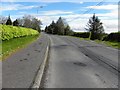
Greencastle Road, Sheskinshule
Heading north-east
Image: © Kenneth Allen
Taken: 24 May 2013
0.02 miles
2
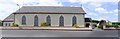
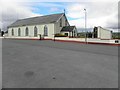
Greencastle RC Church
It is located to the east of the hamlet.
Image: © Kenneth Allen
Taken: 14 Jul 2006
0.08 miles
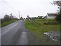
3
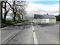
Greencastle Road
Heading WSW towards Greencastle
Image: © Kenneth Allen
Taken: 24 May 2013
0.08 miles
4
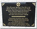
Plaque, St Patrick's Hall
Pictured here Image]
Image: © Kenneth Allen
Taken: 24 May 2013
0.10 miles
5
RC Church, Greencastle
My attention was drawn to the plaque on the wall here Image]
Image: © Kenneth Allen
Taken: 24 May 2013
0.11 miles
6
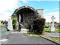
Holy shrine near Greencastle
Pictured here Image]
Image: © Kenneth Allen
Taken: 24 May 2013
0.13 miles
7
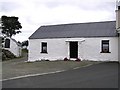
Cottage at Greencastle
It is along the roadside and is still inhabited.
Image: © Kenneth Allen
Taken: 7 Aug 2006
0.15 miles
8
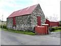
Stone barn, Sheskinshule
Pictured along Greencastle Road
Image: © Kenneth Allen
Taken: 24 May 2013
0.15 miles
9
A crest ahead on Greencastle Road
Heading south-west
Image: © Kenneth Allen
Taken: 24 May 2013
0.17 miles
10
Greencastle Road
Heading SSW towards the hamlet
Image: © Kenneth Allen
Taken: 29 Oct 2009
0.17 miles