IMAGES TAKEN NEAR TO
Killyclogher Road, OMAGH, BT79 7PN
Introduction
This page details the photographs taken nearby to Killyclogher Road, BT79 7PN by members of the Geograph project.
The Geograph project started in 2005 with the aim of publishing, organising and preserving representative images for every square kilometre of Great Britain, Ireland and the Isle of Man.

There are currently over 7.5m images from over14,400 individuals and you can help contribute to the project by visiting https://www.geograph.org.uk
Image Map
Images are licensed for reuse under creativecommons.org/licenses/by-sa/2.0
Notes
- Clicking on the map will re-center to the selected point.
- The higher the marker number, the further away the image location is from the centre of the postcode.
Image Listing (86 Images Found)
Images are licensed for reuse under creativecommons.org/licenses/by-sa/2.0
Image
Details
Distance
1
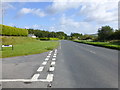
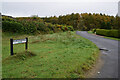
A505 Killyclogher / Barony Road, Faccary
Heading north-east towards Cooketown
Image: © Kenneth Allen
Taken: 26 Sep 2014
0.05 miles
2
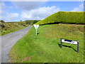
Vandalised road sign, Faccary
It is the sign for Killins Road
Image: © Kenneth Allen
Taken: 26 Sep 2014
0.05 miles
3
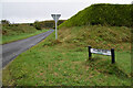
Killins Road, Faccary
Heading NNW from Killyclogher Road
Note spelling is Killens, different from the other road sign Image]
Image: © Kenneth Allen
Taken: 28 Oct 2021
0.05 miles
4
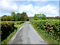
Minor road, Faccary
Heading north-west
Image: © Kenneth Allen
Taken: 26 Sep 2014
0.06 miles
5
Killyclogher Road, Faccary
Heading NNW from the main Killyclogher Road
Image: © Kenneth Allen
Taken: 28 Oct 2021
0.08 miles
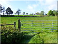
7
Killins Townland
Pictured along Mountfield Road
Image: © Kenneth Allen
Taken: 26 Sep 2014
0.11 miles
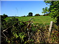
9
Racolpa Townland
Looking north-east in the direction of Mountfield
Image: © Kenneth Allen
Taken: 21 Jan 2009
0.12 miles
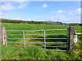
10
Killyclogher Road, Killins
Bending north towards Mountfield
Image: © Kenneth Allen
Taken: 26 Sep 2014
0.12 miles