IMAGES TAKEN NEAR TO
Mountjoy Road, OMAGH, BT79 7BE
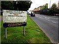
Introduction
This page details the photographs taken nearby to Mountjoy Road, BT79 7BE by members of the Geograph project.
The Geograph project started in 2005 with the aim of publishing, organising and preserving representative images for every square kilometre of Great Britain, Ireland and the Isle of Man.

There are currently over 7.5m images from over14,400 individuals and you can help contribute to the project by visiting https://www.geograph.org.uk
Image Map
Images are licensed for reuse under creativecommons.org/licenses/by-sa/2.0
Notes
- Clicking on the map will re-center to the selected point.
- The higher the marker number, the further away the image location is from the centre of the postcode.
Image Listing (1707 Images Found)
Images are licensed for reuse under creativecommons.org/licenses/by-sa/2.0
Image
Details
Distance
1
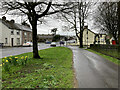
Daffodils along Mountjoy Road, Omagh
Heading south at Lisnamallard
Image: © Kenneth Allen
Taken: 29 Mar 2021
0.00 miles
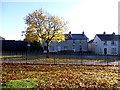
2
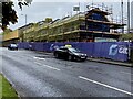
New housing site, Mountjoy Road, Omagh
Built on the site of the former Police Station
Image: © Kenneth Allen
Taken: 21 Aug 2024
0.01 miles
3
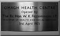
Plaque, Omagh Health Centre
It reads, "Omagh Health Centre. Opened by The Rt Hon. W.K. Fitzimmons, J.P. Minister of Health and Social Services 3rd April, 1971" and it is located here Image]
Image: © Kenneth Allen
Taken: 30 Dec 2008
0.01 miles
4
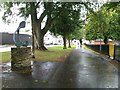
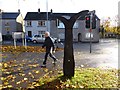
Wishbone sculpture, Omagh (2)
Looking south; Omagh District Council and grounds are to the right
Image: © Kenneth Allen
Taken: 10 Sep 2012
0.01 miles
5
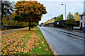
Fallen leaves along Mountjoy Road, Omagh
Heading north towards Gortin Road
Image: © Kenneth Allen
Taken: 19 Oct 2020
0.01 miles
6
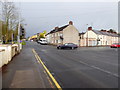
Crossroads, Mountjoy Road, Omagh
The intersection with Lisanelly Avenue and Old Mountfield Road
The car turning round the corner is passing the site of the former "Bull's-Eye" Image]
Image: © Kenneth Allen
Taken: 31 Jan 2018
0.01 miles
7
National Cycle Route, Omagh
Pictured along Gortin Road
Image: © Kenneth Allen
Taken: 18 Nov 2013
0.01 miles
8
Grange Park, Omagh
Looking east towards Gortin Road
Image: © Kenneth Allen
Taken: 18 Nov 2013
0.01 miles
9
Sign, National Cycle Network, B48 Gortin Road, Omagh
Though it says Gortin Road, it is still Mountjoy Road until you reach "The Gussett" further along at the junction with Killybrack Road
Image: © Kenneth Allen
Taken: 18 Jul 2016
0.01 miles
10
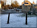
Frosty "Crossroads", Omagh
It is located at the intersection of the Mountjoy Road, Lisanelly Avenue and the Old Mountjoy Road; the car is passing the corner where the "Bull's-eye" used to be before it was deemed to be a traffic hazard and removed - see Image] and
Image]
Image: © Kenneth Allen
Taken: 4 Jan 2010
0.01 miles