IMAGES TAKEN NEAR TO
Mountjoy Road, OMAGH, BT79 7AY
Introduction
This page details the photographs taken nearby to Mountjoy Road, BT79 7AY by members of the Geograph project.
The Geograph project started in 2005 with the aim of publishing, organising and preserving representative images for every square kilometre of Great Britain, Ireland and the Isle of Man.

There are currently over 7.5m images from over14,400 individuals and you can help contribute to the project by visiting https://www.geograph.org.uk
Image Map
Images are licensed for reuse under creativecommons.org/licenses/by-sa/2.0
Notes
- Clicking on the map will re-center to the selected point.
- The higher the marker number, the further away the image location is from the centre of the postcode.
Image Listing (2542 Images Found)
Images are licensed for reuse under creativecommons.org/licenses/by-sa/2.0
Image
Details
Distance
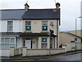
2
Former fire station, Omagh
Pictured along Mountjoy Road
Image: © Kenneth Allen
Taken: 26 Feb 2016
0.01 miles
3
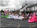
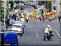
2011 Mid Summer Carnival, Omagh (18)
Colourful costumes parading at "Crossroads", the junction of Mountjoy Road, Lisanelly Avenue and Old Mountfield Road
Image: © Kenneth Allen
Taken: 18 Jun 2011
0.01 miles
4
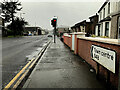
RNIB, Omagh
It is located along Mountjoy Road
See close-up of notice here Image]
Image: © Kenneth Allen
Taken: 25 Apr 2013
0.01 miles
5
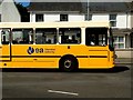
EA bus, Omagh
Pictured along Mountjoy Road
Most of the schools are on their summer break now.
Image: © Kenneth Allen
Taken: 18 Jul 2016
0.01 miles
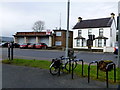
6
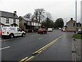
Mountjoy Road, Omagh
Heading SSW towards the town centre
Image: © Kenneth Allen
Taken: 16 Feb 2023
0.01 miles
7

2011 Mid Summer Carnival, Omagh (19)
The Mad Hatters Samba Group in full swing
Image: © Kenneth Allen
Taken: 18 Jun 2011
0.01 miles
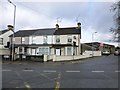
8
B46 Mountjoy Road, Omagh
Heading NNE towards the road junction known locally as Crossroads and the location of the "Bull's Eye" Image]
Beyond is the Gortin Road leading to Gortin village, which is about 8 miles away. It takes you past Gortin Glens, a scenic forest park.
Image: © Kenneth Allen
Taken: 20 Feb 2012
0.01 miles
9
"Crossroads", Omagh
The junction of Lisanelly Avenue, Gortin Road, Old Mountfield Road and Mountjoy Road. Omagh Health Centre is in the background.
This is the area of the town that would come under the Lisnamallard Townland
Image: © Kenneth Allen
Taken: 10 Sep 2012
0.01 miles
10
The parade is coming, Omagh!
I have zoomed from my position on Bells Bridge towards "Crossroads" which is another square along Mountjoy Avenue
More at Image]
Image: © Kenneth Allen
Taken: 22 Jun 2013
0.01 miles