IMAGES TAKEN NEAR TO
Moylagh Road, OMAGH, BT79 0UN
Introduction
This page details the photographs taken nearby to Moylagh Road, BT79 0UN by members of the Geograph project.
The Geograph project started in 2005 with the aim of publishing, organising and preserving representative images for every square kilometre of Great Britain, Ireland and the Isle of Man.

There are currently over 7.5m images from over14,400 individuals and you can help contribute to the project by visiting https://www.geograph.org.uk
Image Map
Images are licensed for reuse under creativecommons.org/licenses/by-sa/2.0
Notes
- Clicking on the map will re-center to the selected point.
- The higher the marker number, the further away the image location is from the centre of the postcode.
Image Listing (86 Images Found)
Images are licensed for reuse under creativecommons.org/licenses/by-sa/2.0
Image
Details
Distance
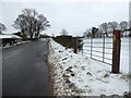
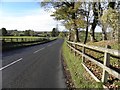
1
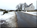
Snow along Moylagh Road
Heading west towards the A5
Image: © Kenneth Allen
Taken: 2 Mar 2018
0.01 miles
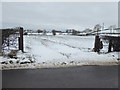
2
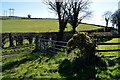
Gates, Curr
Pictured along Moylagh Road
Image: © Kenneth Allen
Taken: 19 Mar 2022
0.02 miles
3
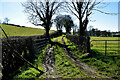
Lane, Curr
Heading south-west from Moylagh Road
Image: © Kenneth Allen
Taken: 19 Mar 2022
0.02 miles
4
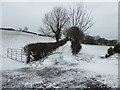
Lane, Curr
Heading south-west from Moylagh Road
Image: © Kenneth Allen
Taken: 2 Mar 2018
0.03 miles
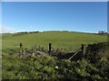
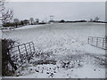
6
An open field, Curr
Pictured along Moylagh Road
Image: © Kenneth Allen
Taken: 2 Mar 2018
0.04 miles
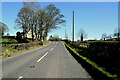
9
Moylagh Road, Curr
Heading west, no footpaths or verges to stand back on along here and the traffic was fast. I was relying on my eyes, ears and high vis jacket to stay safe
Image: © Kenneth Allen
Taken: 1 Nov 2012
0.07 miles
10
Open gates, Curr
Pictured along Moylagh Road
Image: © Kenneth Allen
Taken: 2 Mar 2018
0.09 miles