IMAGES TAKEN NEAR TO
Radergan Road, OMAGH, BT79 0TX
Introduction
This page details the photographs taken nearby to Radergan Road, BT79 0TX by members of the Geograph project.
The Geograph project started in 2005 with the aim of publishing, organising and preserving representative images for every square kilometre of Great Britain, Ireland and the Isle of Man.

There are currently over 7.5m images from over14,400 individuals and you can help contribute to the project by visiting https://www.geograph.org.uk
Image Map
Images are licensed for reuse under creativecommons.org/licenses/by-sa/2.0
Notes
- Clicking on the map will re-center to the selected point.
- The higher the marker number, the further away the image location is from the centre of the postcode.
Image Listing (87 Images Found)
Images are licensed for reuse under creativecommons.org/licenses/by-sa/2.0
Image
Details
Distance
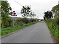
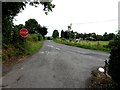
1
Lower Radergan Road, Beragh
Heading SSW
Image: © Kenneth Allen
Taken: 2 May 2018
0.01 miles
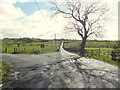
2
Radergan Road and Lower Radergan Road
Heading south from Beragh
Image: © Kenneth Allen
Taken: 23 Oct 2012
0.01 miles
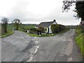
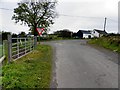
4
Road junction, Beragh
Lower Radergan Road joins Radergan Road
Image: © Kenneth Allen
Taken: 30 Jul 2013
0.01 miles
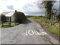
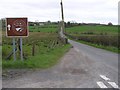
5
Marshall Trail (6.3) Radergan Road, Beragh
Following the trail sign southwards - a challenge taking pictured against the sun
Image: © Kenneth Allen
Taken: 24 Mar 2015
0.02 miles
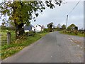
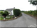
6
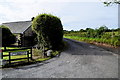
Lower Radergan Road
Heading south from Radergan Road
Image: © Kenneth Allen
Taken: 10 Sep 2019
0.02 miles
8
Halligan Road
Heading WSW towards Radergan Road
Image: © Kenneth Allen
Taken: 23 Oct 2012
0.03 miles
9
Lower Radergan Road, Beragh
Heading south from Radergan Road
Image: © Kenneth Allen
Taken: 30 Jul 2013
0.03 miles