IMAGES TAKEN NEAR TO
Hutton Drive, OMAGH, BT79 0SR
Introduction
This page details the photographs taken nearby to Hutton Drive, BT79 0SR by members of the Geograph project.
The Geograph project started in 2005 with the aim of publishing, organising and preserving representative images for every square kilometre of Great Britain, Ireland and the Isle of Man.

There are currently over 7.5m images from over14,400 individuals and you can help contribute to the project by visiting https://www.geograph.org.uk
Image Map
Images are licensed for reuse under creativecommons.org/licenses/by-sa/2.0
Notes
- Clicking on the map will re-center to the selected point.
- The higher the marker number, the further away the image location is from the centre of the postcode.
Image Listing (270 Images Found)
Images are licensed for reuse under creativecommons.org/licenses/by-sa/2.0
Image
Details
Distance
1
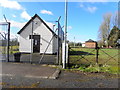
Marshall Trail (6.2) Telephone Exchange, Beragh
In the background is the derelict primary school Image]
Image: © Kenneth Allen
Taken: 24 Mar 2015
0.01 miles
2
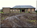
Derelict school, Beragh
Hutton Primary School is due to be demolished very soon to make way for a housing development
A previous view Image]
Image: © Kenneth Allen
Taken: 18 Apr 2016
0.02 miles
3

Hutton Controlled Primary School, Beragh
And to think I spent hundreds of pounds on this property when I was employed by the Western Education and Library Board, before it was closed down and the new Cooley Primary School opened at Sixmilecross
Image: © Kenneth Allen
Taken: 20 Oct 2008
0.02 miles
4
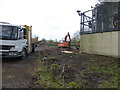
Site work at the former primary school, Beragh
It adjoins the police station with is also vacant
Image: © Kenneth Allen
Taken: 18 Apr 2016
0.03 miles
5

Plaque, G.W. Gibson, Beragh
The inscription on this small plaque indicates that the previous owner was a Mr H Cadwell and the business was taken over on 1st February, 1957 by its present owners; see image of shop here Image]
Image: © Kenneth Allen
Taken: 20 Oct 2008
0.04 miles
6
Hutton Primary School, Beragh
This property has deteriorated even more since I last pictured it in October, 2008 Image
Image: © Kenneth Allen
Taken: 18 Jan 2011
0.04 miles
7
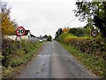
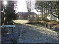
Radergan Road, Beragh
Heading NNW towards the village
Image: © Kenneth Allen
Taken: 23 Oct 2012
0.04 miles
8
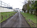
Entrance to former school.Beragh
Heading north towards the Main Street
The concrete bollards won't be much longer
A previous view from the opposite direction Image]
Image: © Kenneth Allen
Taken: 18 Apr 2016
0.04 miles
9
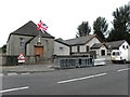
Halls, Beragh
Image: © Kenneth Allen
Taken: 30 Jul 2013
0.04 miles
10
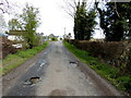
Radergan Road, Beragh
Heading NNW towards Main Street, Beragh
Image: © Kenneth Allen
Taken: 2 May 2018
0.04 miles