IMAGES TAKEN NEAR TO
Donaghanie Road, OMAGH, BT79 0RZ
Introduction
This page details the photographs taken nearby to Donaghanie Road, BT79 0RZ by members of the Geograph project.
The Geograph project started in 2005 with the aim of publishing, organising and preserving representative images for every square kilometre of Great Britain, Ireland and the Isle of Man.

There are currently over 7.5m images from over14,400 individuals and you can help contribute to the project by visiting https://www.geograph.org.uk
Image Map
Images are licensed for reuse under creativecommons.org/licenses/by-sa/2.0
Notes
- Clicking on the map will re-center to the selected point.
- The higher the marker number, the further away the image location is from the centre of the postcode.
Image Listing (66 Images Found)
Images are licensed for reuse under creativecommons.org/licenses/by-sa/2.0
Image
Details
Distance
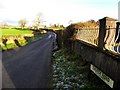
1
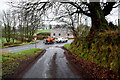
Church Road, Clogherny Glebe Lower
Heading east
A car passes by on Donaghanie Road
Image: © Kenneth Allen
Taken: 21 Jan 2020
0.00 miles
2
Church Road, Coolesker
Heading east from Donaghanie Road
Image: © Kenneth Allen
Taken: 21 Jan 2020
0.01 miles
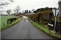
3
Marshall Trail (4.1) - Donaghanie Road, Clogherny
Heading SSE towards the next stop at Beragh Village
I see the Orange Hall building is for sale
Image: © Kenneth Allen
Taken: 24 Mar 2015
0.02 miles
4
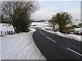
Donaghanie Road
The main routes are well clear of snow, but it is different matter with the side roads - see Image]
Image: © Kenneth Allen
Taken: 26 Dec 2009
0.02 miles
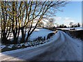
6

Church Road, Coolesker
Looking ENE from the Donaghanie Road
Image: © Kenneth Allen
Taken: 30 Jan 2010
0.03 miles
7
Church Road, Clogherny Glebe Lower
Looking east at one of many untreated side roads in the area
Image: © Kenneth Allen
Taken: 1 Dec 2010
0.04 miles
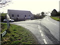
8
B158 Donaghanie Road, Clogherny Glebe Lower
Heading NNW from the intersection with Church Road
Image: © Kenneth Allen
Taken: 21 Jan 2020
0.04 miles
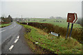
9
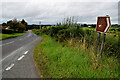
Donaghanie Road, Coolesker
Heading NNW towards Omagh; the sign on the right is one of many that are round the area centred in Sixmilecross, stretching as far as Omagh and Carrickmore, that indicate the W.F. Marshall trail.
Image: © Kenneth Allen
Taken: 30 Jan 2010
0.04 miles
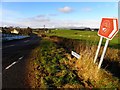
10
Donaghanie Road
Heading NNW at Clogherny Glebe Lower
Image: © Kenneth Allen
Taken: 17 Aug 2024
0.04 miles