IMAGES TAKEN NEAR TO
Roscavey Road, OMAGH, BT79 0RF
Introduction
This page details the photographs taken nearby to Roscavey Road, BT79 0RF by members of the Geograph project.
The Geograph project started in 2005 with the aim of publishing, organising and preserving representative images for every square kilometre of Great Britain, Ireland and the Isle of Man.

There are currently over 7.5m images from over14,400 individuals and you can help contribute to the project by visiting https://www.geograph.org.uk
Image Map
Images are licensed for reuse under creativecommons.org/licenses/by-sa/2.0
Notes
- Clicking on the map will re-center to the selected point.
- The higher the marker number, the further away the image location is from the centre of the postcode.
Image Listing (39 Images Found)
Images are licensed for reuse under creativecommons.org/licenses/by-sa/2.0
Image
Details
Distance
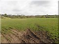
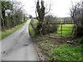
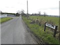
3
Roscavey Road, Roscavey
Heading SSE towards Brackagh
Image: © Kenneth Allen
Taken: 1 Mar 2013
0.12 miles
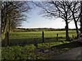
4
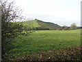
Brackagh Townland
A small green mountain in the background
Image: © Kenneth Allen
Taken: 3 Jan 2006
0.13 miles
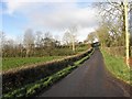
5
Roscavey Road
Heading south-east at Roscavey
Image: © Kenneth Allen
Taken: 1 Mar 2013
0.13 miles
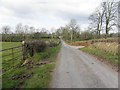
6
Brackagh Townland
Viewed along the Roscavey Road
Image: © Kenneth Allen
Taken: 26 Nov 2009
0.13 miles
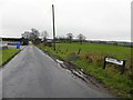
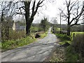
8
Roscavey Road, Roscavey
Heading north-west
Image: © Kenneth Allen
Taken: 1 Mar 2013
0.14 miles
9
Roscavey Road
Heading south-east from Clogherny Road
Image: © Kenneth Allen
Taken: 1 Mar 2013
0.15 miles
10
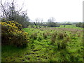
Rushy ground, Roscavey
Pictured along Clogherny Road
Image: © Kenneth Allen
Taken: 4 Apr 2017
0.16 miles