IMAGES TAKEN NEAR TO
Hazelwood Cranny, OMAGH, BT79 0PX
Introduction
This page details the photographs taken nearby to Hazelwood Cranny, BT79 0PX by members of the Geograph project.
The Geograph project started in 2005 with the aim of publishing, organising and preserving representative images for every square kilometre of Great Britain, Ireland and the Isle of Man.

There are currently over 7.5m images from over14,400 individuals and you can help contribute to the project by visiting https://www.geograph.org.uk
Image Map
Images are licensed for reuse under creativecommons.org/licenses/by-sa/2.0
Notes
- Clicking on the map will re-center to the selected point.
- The higher the marker number, the further away the image location is from the centre of the postcode.
Image Listing (4243 Images Found)
Images are licensed for reuse under creativecommons.org/licenses/by-sa/2.0
Image
Details
Distance
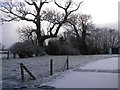
1
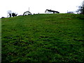
Houses behind a hill, Mullaghmore
Looking north-west
Image: © Kenneth Allen
Taken: 7 Mar 2017
0.01 miles
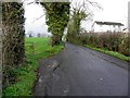
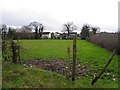
2
Lane-way, near Cranny Mill
Heading along side the Ballynamullan Burn towards Mullaghmore
Image: © Kenneth Allen
Taken: 20 Jan 2008
0.02 miles
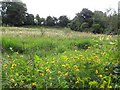
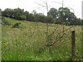
5
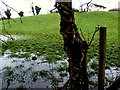
Waterlogged ground, Mullaghmore
Looking NNW
Image: © Kenneth Allen
Taken: 7 Mar 2017
0.03 miles
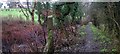
6
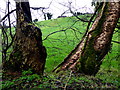
Tree trunks, Mullaghmore
Pictured along Ballinamullan Burn
Image: © Kenneth Allen
Taken: 7 Mar 2017
0.03 miles
8
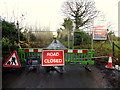
Road Closed notice, Cranny
Riverview Road heads NNE from here
The gas pipeline contract is taking place here
Image: © Kenneth Allen
Taken: 6 Dec 2018
0.03 miles