IMAGES TAKEN NEAR TO
Mulnafye Road, OMAGH, BT79 0PG
Introduction
This page details the photographs taken nearby to Mulnafye Road, BT79 0PG by members of the Geograph project.
The Geograph project started in 2005 with the aim of publishing, organising and preserving representative images for every square kilometre of Great Britain, Ireland and the Isle of Man.

There are currently over 7.5m images from over14,400 individuals and you can help contribute to the project by visiting https://www.geograph.org.uk
Image Map
Images are licensed for reuse under creativecommons.org/licenses/by-sa/2.0
Notes
- Clicking on the map will re-center to the selected point.
- The higher the marker number, the further away the image location is from the centre of the postcode.
Image Listing (35 Images Found)
Images are licensed for reuse under creativecommons.org/licenses/by-sa/2.0
Image
Details
Distance
3
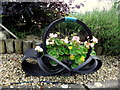
Flower basket, Oxtown
On closer inspection, I noticed that it was formed out of an old tyre
Pictured here Image]
Image: © Kenneth Allen
Taken: 31 Aug 2015
0.05 miles
4
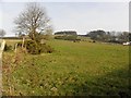
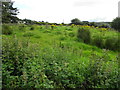
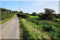
Mulnafye Townland
Looking north from Mulnafye Road
Image: © Kenneth Allen
Taken: 18 Sep 2020
0.06 miles
5
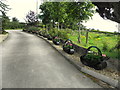
Line of flower baskets along a driveway, Oxtown
See close-up here Image]
Image: © Kenneth Allen
Taken: 31 Aug 2015
0.06 miles
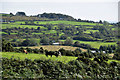
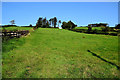
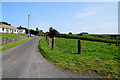
6
Mulnafye Road, Mulnafye / Oxtown
Heading ENE towards Glen Upper
Image: © Kenneth Allen
Taken: 18 Sep 2020
0.08 miles
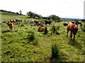
7
Mulnafye Road, Mulnafye / Oxtown
Heading ENE
Image: © Kenneth Allen
Taken: 18 Sep 2020
0.08 miles