IMAGES TAKEN NEAR TO
Farmhill Road, OMAGH, BT79 0JW
Introduction
This page details the photographs taken nearby to Farmhill Road, BT79 0JW by members of the Geograph project.
The Geograph project started in 2005 with the aim of publishing, organising and preserving representative images for every square kilometre of Great Britain, Ireland and the Isle of Man.

There are currently over 7.5m images from over14,400 individuals and you can help contribute to the project by visiting https://www.geograph.org.uk
Image Map
Images are licensed for reuse under creativecommons.org/licenses/by-sa/2.0
Notes
- Clicking on the map will re-center to the selected point.
- The higher the marker number, the further away the image location is from the centre of the postcode.
Image Listing (72 Images Found)
Images are licensed for reuse under creativecommons.org/licenses/by-sa/2.0
Image
Details
Distance
1
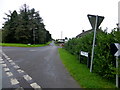
Donkeys, Arvalee
Pictured along Arvalee Road
Image: © Kenneth Allen
Taken: 4 May 2022
0.11 miles
2
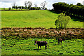
Donkeys, Arvalee
Pictured along Arvalee Road
Image: © Kenneth Allen
Taken: 9 May 2023
0.11 miles
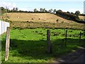
3
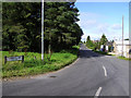
Daffodils along Farmhill Road
Looking WNW at Arvalee
Image: © Kenneth Allen
Taken: 25 Mar 2020
0.13 miles
4
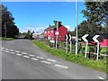
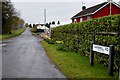
Farmhill Road, Arvalee
Heading WNW from the junction with Arvalee Road and Deverney Road
Image: © Kenneth Allen
Taken: 21 Sep 2012
0.13 miles
7
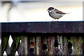
House sparrow on a wall, Arvalee
Pictured very quickly!
Image: © Kenneth Allen
Taken: 4 Nov 2018
0.14 miles
8
Arvalee Townland
Baa, baa, black sheep?
Image: © Kenneth Allen
Taken: 11 Aug 2009
0.14 miles
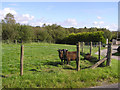
9
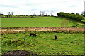
Cattle in field, Arvalee
Looks like they could escape through the missing wire in the fence
Image: © Kenneth Allen
Taken: 11 Aug 2009
0.14 miles