IMAGES TAKEN NEAR TO
Doogary Road, OMAGH, BT79 0HE
Introduction
This page details the photographs taken nearby to Doogary Road, BT79 0HE by members of the Geograph project.
The Geograph project started in 2005 with the aim of publishing, organising and preserving representative images for every square kilometre of Great Britain, Ireland and the Isle of Man.

There are currently over 7.5m images from over14,400 individuals and you can help contribute to the project by visiting https://www.geograph.org.uk
Image Map
Images are licensed for reuse under creativecommons.org/licenses/by-sa/2.0
Notes
- Clicking on the map will re-center to the selected point.
- The higher the marker number, the further away the image location is from the centre of the postcode.
Image Listing (33 Images Found)
Images are licensed for reuse under creativecommons.org/licenses/by-sa/2.0
Image
Details
Distance
1
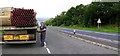
Checking the load, A5, near Tattykeel
Just to be sure. This is a very busy stretch of road.
Image: © Kenneth Allen
Taken: 6 Sep 2007
0.01 miles

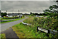
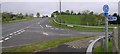
3
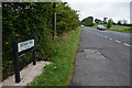
Doogary Road, Tattykeel
Heading north-west towards Omagh
Image: © Kenneth Allen
Taken: 24 Jul 2024
0.08 miles
4
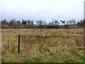
Vacant land, Tattykeel
It lies between the Doogary Road and the old road
Image: © Kenneth Allen
Taken: 27 Jan 2014
0.10 miles
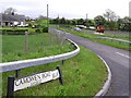
5
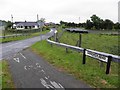
Camowen Road, Ranelly
Heading north-east from Doogary Road
Image: © Kenneth Allen
Taken: 27 Jun 2013
0.10 miles
6
Camowen Road, Ranelly
Heading ENE from Doogary Road
Image: © Kenneth Allen
Taken: 24 Jul 2024
0.10 miles
7
Camowen Road
It is in the townland of Ranelly
Image: © Kenneth Allen
Taken: 17 May 2007
0.11 miles
8
Old road at Tattykeel
This used to be the main road from Omagh to Ballygawley
Image: © Kenneth Allen
Taken: 27 Jan 2014
0.11 miles
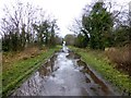
9
Uneven road, Tattykeel
It runs north-west parallel with the A5 Doogary Road
There is bogland to the left of it, in which the peat is being harvested for garden compost. Not many of these areas remain.
Image: © Kenneth Allen
Taken: 27 Jan 2014
0.12 miles
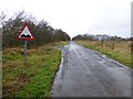
10
A5 at Tattykeel
A new National Cycling Network sign has been erected on the right. The main road leads to Omagh
Image: © Kenneth Allen
Taken: 17 May 2007
0.13 miles