IMAGES TAKEN NEAR TO
Crevenagh Road, OMAGH, BT79 0EQ
Introduction
This page details the photographs taken nearby to Crevenagh Road, BT79 0EQ by members of the Geograph project.
The Geograph project started in 2005 with the aim of publishing, organising and preserving representative images for every square kilometre of Great Britain, Ireland and the Isle of Man.

There are currently over 7.5m images from over14,400 individuals and you can help contribute to the project by visiting https://www.geograph.org.uk
Image Map
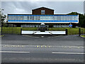
Images are licensed for reuse under creativecommons.org/licenses/by-sa/2.0
Notes
- Clicking on the map will re-center to the selected point.
- The higher the marker number, the further away the image location is from the centre of the postcode.
Image Listing (2502 Images Found)
Images are licensed for reuse under creativecommons.org/licenses/by-sa/2.0
Image
Details
Distance
1
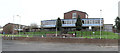
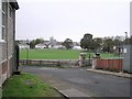
Omagh High School site
It is located on the Crevenagh Road, which is being altered in a road widening scheme. Part of the school is included in H4572 and the main body is in H4672
Image: © Kenneth Allen
Taken: 3 Jan 2006
0.03 miles
2
Omagh High School site
Looking east from H4572 across Crevenagh Road.
The boundary fence of the site and the front wall of the kitchen are within H4572 but the school is about a metre inside H4672.
Image: © Kenneth Allen
Taken: 17 Feb 2012
0.03 miles
3
Front entrance to Omagh High School
Pictured along Crevenagh Road
The school building located behind the fence is in the adjoining square H4672
Image: © Kenneth Allen
Taken: 28 Dec 2019
0.03 miles
4
New houses on Crevenagh Road, Omagh
The houses to the left used to be staff accommodation and they were sold off and re-built by a private contractor. The yellow building on the far right is the main block of the Education Board buildings, whilst the brick building to the right is one of the Crafts Block of Omagh High School.
Image: © Kenneth Allen
Taken: 22 Oct 2006
0.03 miles
5
Looking towards Omagh
Taken from the side of Omagh High School. The school canteen is on the left.
Image: © Kenneth Allen
Taken: 22 Oct 2006
0.03 miles
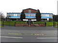
6
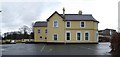
Campsie House, Omagh
Located at 1 Hospital Road and built circa 1901, it was the home of the Fleming family. This family owned land from Campsie to Cranny Bridge on the right hand side of the Hospital Road.They also owned the land where the persent tennis club is off the Crevenagh Road. This house is now the headquarters of the Western Education and Library Board. In the background to the right is Omagh High School
Image: © Kenneth Allen
Taken: 24 Nov 2007
0.03 miles
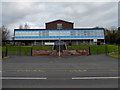
7
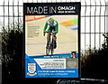
Made in Omagh High School poster
There are several of posters located along the front fence featuring past pupils celebrating various achievements
One of them was Marc Potts
"Represented Nl in the Commonwealth Games in 2018, Goldcoast Australia, First person to compete in 3 disciplines (Road 28th place, Mountain Bike 17th place and Track 12th place)."
Pictured here Image]
Image: © Kenneth Allen
Taken: 18 Mar 2021
0.03 miles
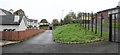
8
Security fence, Omagh High School
Pictured along Crevenagh Road
Image: © Kenneth Allen
Taken: 14 Oct 2017
0.03 miles
9
Omagh High School entrance
Pictured along Crevenagh Road
The boundary fence and canteen are included in this square but the main school building is in the square behind
Image: © Kenneth Allen
Taken: 22 Jul 2024
0.03 miles
10
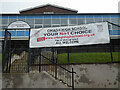
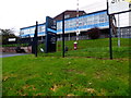
Banner, Omagh High School
It is located at the pedestrian entrance
Note: the main body of the school is in the adjoining square
Image: © Kenneth Allen
Taken: 1 Mar 2021
0.03 miles