IMAGES TAKEN NEAR TO
Beltany Road, OMAGH, BT78 5RB
Introduction
This page details the photographs taken nearby to Beltany Road, BT78 5RB by members of the Geograph project.
The Geograph project started in 2005 with the aim of publishing, organising and preserving representative images for every square kilometre of Great Britain, Ireland and the Isle of Man.

There are currently over 7.5m images from over14,400 individuals and you can help contribute to the project by visiting https://www.geograph.org.uk
Image Map
Images are licensed for reuse under creativecommons.org/licenses/by-sa/2.0
Notes
- Clicking on the map will re-center to the selected point.
- The higher the marker number, the further away the image location is from the centre of the postcode.
Image Listing (43 Images Found)
Images are licensed for reuse under creativecommons.org/licenses/by-sa/2.0
Image
Details
Distance
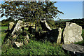
2
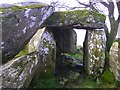
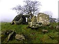
Chambered grave, Beltany (6)
A detail of the cap-stone
Image: © Kenneth Allen
Taken: 23 Jan 2010
0.06 miles
3
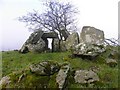
Chambered grave, Beltany (4)
Looking north
Image: © Kenneth Allen
Taken: 23 Jan 2010
0.06 miles
4
Chambered grave, Beltany (5)
Looking NNW
Image: © Kenneth Allen
Taken: 23 Jan 2010
0.06 miles
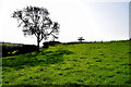
5
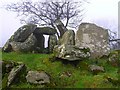
Chambered grave, Beltany (1)
At last I was able to re-discover this ancient site. This site is so hidden that some of the locals are not aware of it
Image: © Kenneth Allen
Taken: 23 Jan 2010
0.08 miles
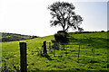
8
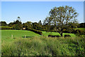
Roller, Beltany
Located in the corner of a field
Image: © Kenneth Allen
Taken: 18 Sep 2020
0.12 miles
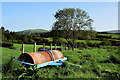
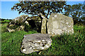
9
Chambered grave, Beltany
Some of the capstones are still in place
Image: © Kenneth Allen
Taken: 18 Sep 2020
0.12 miles
10
Large stones at Beltany Chambered Grave
Hidden in a corner of a field
Image: © Kenneth Allen
Taken: 18 Sep 2020
0.13 miles