IMAGES TAKEN NEAR TO
Beltany Road, OMAGH, BT78 5QT
Introduction
This page details the photographs taken nearby to Beltany Road, BT78 5QT by members of the Geograph project.
The Geograph project started in 2005 with the aim of publishing, organising and preserving representative images for every square kilometre of Great Britain, Ireland and the Isle of Man.

There are currently over 7.5m images from over14,400 individuals and you can help contribute to the project by visiting https://www.geograph.org.uk
Image Map
Images are licensed for reuse under creativecommons.org/licenses/by-sa/2.0
Notes
- Clicking on the map will re-center to the selected point.
- The higher the marker number, the further away the image location is from the centre of the postcode.
Image Listing (6 Images Found)
Images are licensed for reuse under creativecommons.org/licenses/by-sa/2.0
Image
Details
Distance
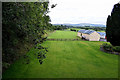
1

A large field, Tantramurry
Looking west. The River Strule is along the line of trees
Image: © Kenneth Allen
Taken: 2 Aug 2016
0.21 miles
2
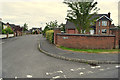
Bell View, Tattraconnaghty
Pictured along Mountjoy Avenue
The Bell refers to Bessy Bell, a mountain to the north of here
(The sister mountain is Mary Gray)
Image: © Kenneth Allen
Taken: 29 Jul 2020
0.22 miles
3

Rushy ground, Tantramurry
Looking south
Image: © Kenneth Allen
Taken: 2 Aug 2016
0.24 miles
4
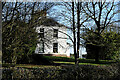
Mountjoy Church Manse, Tattraconnaghty
Located behind the church hall
Image: © Kenneth Allen
Taken: 26 Feb 2024
0.24 miles
5
Line of former railway track, Tattraconnaghty
It was along the left side of the green field, not many traces remain
Image: © Kenneth Allen
Taken: 29 Jul 2020
0.25 miles
