IMAGES TAKEN NEAR TO
Corlea Road, OMAGH, BT78 5LG
Introduction
This page details the photographs taken nearby to Corlea Road, BT78 5LG by members of the Geograph project.
The Geograph project started in 2005 with the aim of publishing, organising and preserving representative images for every square kilometre of Great Britain, Ireland and the Isle of Man.

There are currently over 7.5m images from over14,400 individuals and you can help contribute to the project by visiting https://www.geograph.org.uk
Image Map
Images are licensed for reuse under creativecommons.org/licenses/by-sa/2.0
Notes
- Clicking on the map will re-center to the selected point.
- The higher the marker number, the further away the image location is from the centre of the postcode.
Image Listing (143 Images Found)
Images are licensed for reuse under creativecommons.org/licenses/by-sa/2.0
Image
Details
Distance
1
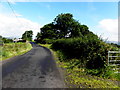
A steep climb, Corlea Road
Heading south-west at Corlea
Image: © Kenneth Allen
Taken: 28 Nov 2020
0.01 miles
2
Muddy along Corlea Road
Heading south-west at Corlea
Image: © Kenneth Allen
Taken: 28 Nov 2020
0.03 miles
4
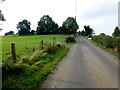
Wind turbine, Corlea
Pictured along Corlea Road
Image: © Kenneth Allen
Taken: 28 Nov 2020
0.06 miles
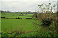
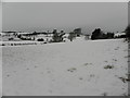
5
Corlea Townland
Looking south-east from Corlea Road
Image: © Kenneth Allen
Taken: 20 Jan 2015
0.06 miles
6
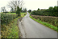
A deep bank and a large hedge along Corlea Road
Heading SSW at Corlea
Image: © Kenneth Allen
Taken: 28 Nov 2020
0.07 miles
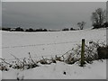
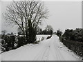
7
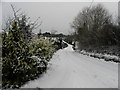
Snow along Corlea Road
You would need a good run at this hill to come up it, thankfully I was using shanks pony.
Image: © Kenneth Allen
Taken: 20 Jan 2015
0.07 miles
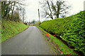
9
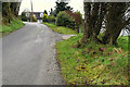
Corlea Road
Heading south-west at Corlea
Image: © Kenneth Allen
Taken: 20 Jan 2015
0.07 miles