IMAGES TAKEN NEAR TO
Ashfield Terrace, OMAGH, BT78 5ES
Introduction
This page details the photographs taken nearby to Ashfield Terrace, BT78 5ES by members of the Geograph project.
The Geograph project started in 2005 with the aim of publishing, organising and preserving representative images for every square kilometre of Great Britain, Ireland and the Isle of Man.

There are currently over 7.5m images from over14,400 individuals and you can help contribute to the project by visiting https://www.geograph.org.uk
Image Map
Images are licensed for reuse under creativecommons.org/licenses/by-sa/2.0
Notes
- Clicking on the map will re-center to the selected point.
- The higher the marker number, the further away the image location is from the centre of the postcode.
Image Listing (5230 Images Found)
Images are licensed for reuse under creativecommons.org/licenses/by-sa/2.0
Image
Details
Distance
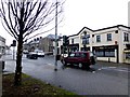
1
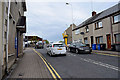
Jail Square, Omagh
Looking south towards the Derry Road
Image: © Kenneth Allen
Taken: 4 Sep 2008
0.01 miles
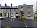
2
Cathal Gormley & Co Accountants, Omagh
They are located at Abbey Terrace, along the Derry Road
The site of the "Rat's Pad" is just up the road Image]
Image: © Kenneth Allen
Taken: 2 Jul 2011
0.01 miles
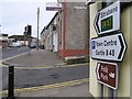
3
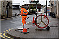
Communications engineer, Abbey Street /Derry Road, Omagh
A new traffic light system is to be installed here
That brush is going to come in useful Image]
Image: © Kenneth Allen
Taken: 3 Jul 2020
0.01 miles
4
McConnell Place, Omagh
Heading north-west from Sedan Avenue to Derry Road
Several years ago, Cinderella lost here shoe here Image]
Image: © Kenneth Allen
Taken: 3 Jan 2014
0.01 miles
5
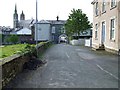
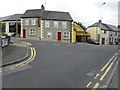
Ashfield Terrace / Castle Place, Omagh
Located along Derry Road
See close-up of street name here Image]
Image: © Kenneth Allen
Taken: 22 Oct 2014
0.01 miles
6
Derry Road, Omagh
Heading WNW at McConnell Place
Image: © Kenneth Allen
Taken: 1 Oct 2009
0.01 miles
7
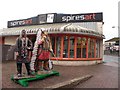
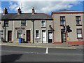
Spires Art, Omagh
Pictured on the Derry Road, the road veering to the left is the Brookmount Road
Image: © Kenneth Allen
Taken: 2 Nov 2009
0.01 miles
8
Junction of Brookmount Road and Derry Road, Omagh
Looking north-east. The narrow entry along Derry Road nicknamed the "Rat's Pad" was located here Image]
Image: © Kenneth Allen
Taken: 19 May 2012
0.01 miles
9
Derry Road, Omagh
Looking ESE. The outline of the Governor's Residence and Jail are on the left and the relatively new building in the centre of screen is a fitness gymnasium. Previously it was a shop Image
Image: © Kenneth Allen
Taken: 22 Oct 2014
0.01 miles