IMAGES TAKEN NEAR TO
Botera Upper Road, OMAGH, BT78 5DG
Introduction
This page details the photographs taken nearby to Botera Upper Road, BT78 5DG by members of the Geograph project.
The Geograph project started in 2005 with the aim of publishing, organising and preserving representative images for every square kilometre of Great Britain, Ireland and the Isle of Man.

There are currently over 7.5m images from over14,400 individuals and you can help contribute to the project by visiting https://www.geograph.org.uk
Image Map
Images are licensed for reuse under creativecommons.org/licenses/by-sa/2.0
Notes
- Clicking on the map will re-center to the selected point.
- The higher the marker number, the further away the image location is from the centre of the postcode.
Image Listing (76 Images Found)
Images are licensed for reuse under creativecommons.org/licenses/by-sa/2.0
Image
Details
Distance
1
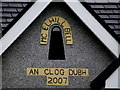
"An Clog Dubh" (The black bell)
This was on the gable of a new bungalow located along here Image]
The McElhill family has connections with Sacred Heart Church in Omagh. The family name is spelt with the Irish version in the book "Poetry in Stone" by Rev. Gerry Convery, where it mentions the handbell, otherwise known as the Black Bell of Drumragh or the McEnhill Bell was rung in front of the funeral procession by the oldest male member of the name in the locality. It was presented to the parish in 1932 by Mr. James McEnhill and in page 165 there is a picture of it mentioning that it is now used on St. Patrick's Day and on all special occasions.
It is thought by some that this bell may have originated from the old church where now is the Drumragh burying ground, about two miles from the town of Omagh Image]
The shape is similar to St. Conall's Bell which was taken from the old monastery at Inniskeel Island Image]
Image: © Kenneth Allen
Taken: 28 Sep 2016
0.01 miles
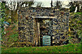
2
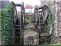
Twin water-wheels, Tattykeel
The basic structure is still intact, but further work is needed to restore these wheels.
Image: © Kenneth Allen
Taken: 18 Nov 2008
0.02 miles
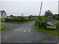
3
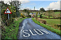
Slaw markings along Botera Road
Heading north-west at Tattykeel
Image: © Kenneth Allen
Taken: 18 Mar 2023
0.02 miles
4
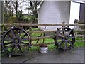
Spiked wheels, Cavanacaw
I think I may have seen a similar set of wheels on an old tractor
Image: © Kenneth Allen
Taken: 18 Nov 2008
0.03 miles
5
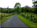
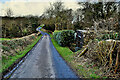
Botera Upper Road, Tattykeel
Heading NNE
Image: © Kenneth Allen
Taken: 28 Sep 2016
0.03 miles
6
Dead-end road, Tattykeel (Rodgers)
Image: © Kenneth Allen
Taken: 28 Sep 2016
0.03 miles
8
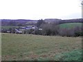
Tattykeel Townland
Looking NNW in the direction of Cavanacaw gold mine - the plateau can be seen in the distance
Image: © Kenneth Allen
Taken: 8 Jan 2013
0.03 miles
9
Botera Road, Tattykeel
Heading NNE
My attention was drawn to Image]
Image: © Kenneth Allen
Taken: 18 Mar 2023
0.03 miles
10
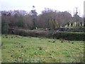
Tattykeel Townland
Looking ESE; in the distance there is a lime kiln Image]
Image: © Kenneth Allen
Taken: 18 Nov 2008
0.03 miles